The Sentier des Douaniers Saint-Florent (Customs Officer’s Path of Saint-Florent) is a sensational 37km coastal trail in the north of Corsica, stretching from Ostriconi in the west to Saint-Florent in the east. One of the most popular trail options is the approx. 16km coastal walk between the famous Saleccia Beach and Saint-Florent via Lotu Beach. This is exactly what Beck and I did!
In this guide, we’ll focus on this popular Sentier des Douaniers Saint-Florent trail option – walking between Saleccia Beach and Saint-Florent.
Table of Contents
Sentier des Douaniers Saint-Florent, Corsica
In northern Corsica, you’ll find the Desert des Agriates, which is one of the largest uninhabited natural areas on the island. Despite this area being defined as desert, its coastal location means it’s not about red, barren soil and dunes but about untouched, pristine beaches and bays amongst shrubland.
The coast of this region features a seaside trail, known as Sentier des Douaniers Saint-Florent. Despite the existence of this trail from Ostriconu to Saint-Florent, you’ll struggle to find any specific trail information online about this entire coastal path. Indeed, not many people will complete the whole coastal trail.
Instead, visitors who want to hike along this coastline will do so generally between Saleccia Beach and Saint-Florent. As this is the walk that Beck and I did and the most popular coastal trail option, we’ll focus on it in our guide.
FYI – because the walk between Saleccia Beach to Saint-Florent is the principal route, it’s commonly referred to as Sentier des Douaniers Saint-Florent. Because of this, in this guide, we’ll sometimes use the name Sentier des Douaniers Saint-Florent to refer to this specific trail option.

Saleccia Beach to Saint-Florent Coastal Walk
So, why is the stretch of coast between Saleccia Beach and Saint-Florent the most popular section of Sentier des Douaniers Saint-Florent? That’s because the most well-known beaches in the Desert des Agriates are Saleccia Beach and the nearby Lotu Beach.


As a result, people will either walk from Saint-Florent to Saleccia Beach via Lotu Beach. They’ll then walk back or take a ferry back from either Saleccia Beach or Lotu Beach to Saint-Florent.
Alternatively, visitors will get a ferry from Saint-Florent to Saleccia Beach, and then walk back. This is what Beck and I chose to do. This is reflected in our guide.
Below, let’s look at the specific trail details for the walk from Saleccia Beach to Saint-Florent.
Saleccia Beach to Saint-Florent Trail Details
- Type: One-way
- Distance: 16km
- Time: 5–6 hours
- Accumulated elevation gain: 200m
- Difficulty: Hard
- Trailhead: Saleccia Beach
- Map: AllTrails
Given the distance, the trail’s exposed nature and the resulting hot weather, this is a challenging coastal walk. There is also a river crossing at Fiume Santu Beach, while trail navigation can be tricky at times. For all of these reasons, we’ve rated the walk as hard.


Sentier des Douaniers Saint-Florent Trail Alternatives
Of course, an even harder option is to do the 32km return walk from Saint-Flotent to Saleccia Beach.
Alternatively, another harder (yet shorter) option is the 24km walk return from Fornali Beach to Saleccia Beach. It’s possible to reach Fornali Beach by car. That’s why some hikers choose to start from there.
FYI – for the easiest and shortest option involving Sentier des Douaniers Saint-Florent, consider walking between Saleccia Beach and Lotu Beach (approx. 4km). It’s possible to get ferries between Saint-Florent, Lotu Beach and Saleccia Beach. This makes this option feasible.
Sentier des Douaniers Saint-Florent Map
Given the route’s popularity between Saleccia Beach and Saint-Florent, the map of Sentier des Douaniers Saint-Florent below shows only this section of the trail.
Feel free to use this AllTrails map to aid navigation.


How to Get to Saint-Florent
The easiest way to get to Saint-Florent is to drive there. There is a bus service between Bastia and Saint-Florent. But this service can be relatively infrequent, especially outside of peak season. This makes public transport an undesirable option.
Beck and I hired a car during our 10 day Corsica trip. We were staying in Bastia when we did this walk. So, we simply drove from Bastia to Saint-Florent.
Car Hire


If you don’t have your own car, you should hire one using Discover Cars. Personally, we use Discover Cars and highly recommend them for finding your ideal car hire at an affordable price. Booking online is super easy and the free cancellation policy is great.
To find out more about renting a car with Discover Cars, read our Discover Cars review and Discover Cars Insurance review.
Parking in Saint-Florent
There are pay-and-display car parks and paid street parking in Saint-Florent. We parked in a large car park called Parking du Centre Ville, next to SPAR de Saint-Florent. Bear in mind, parking there is quite expensive. Luckily, we parked here on a Sunday, when parking is free!
Sentier des Douaniers Saint-Florent Highlights
Let’s look at the highlights of Sentier des Douaniers Saint-Florent, between Saleccia Beach and Saint-Florent.
As mentioned, we caught a ferry (Le Popeye) from Saint-Florent to Saleccia Beach to start this adventure!
Check out the Le Popeye website for the latest details about ferry departure times and prices. Personally, we caught the earliest ferry (10am) running in May and paid €15/person one-way. We booked in advance online, which we highly recommend, especially in peak season, to guarantee a seat.


Ferry From Saint-Florent to Saleccia Beach
After parking in Saint-Florent and collecting our tickets from the Le Popeye kiosk, we were soon whisked away from Port Saint-Florent onto Saleccia Beach.
Following the coastline, the ferry nicely previews the stunning stretch of coast you’re about to explore.


Soon enough, you’ll arrive at the well-renowned Saleccia Beach.
Saleccia Beach (Plage de Saleccia)
Undoubtedly, Saleccia Beach is one of the most beautiful beaches in Corsica, let alone in Europe. In 1962, the beach was used as a filming location for The Longest Day. This has made it one of the most well-known beaches in Europe.
It’s no wonder that some people choose to spend their entire day at Saleccia Beach. Beck and I thoroughly enjoyed walking along and exploring this beach. It was genuinely hard to leave so soon, to carry on with Sentier des Douaniers Saint-Florent. But, with a long walk ahead, it had to be done!


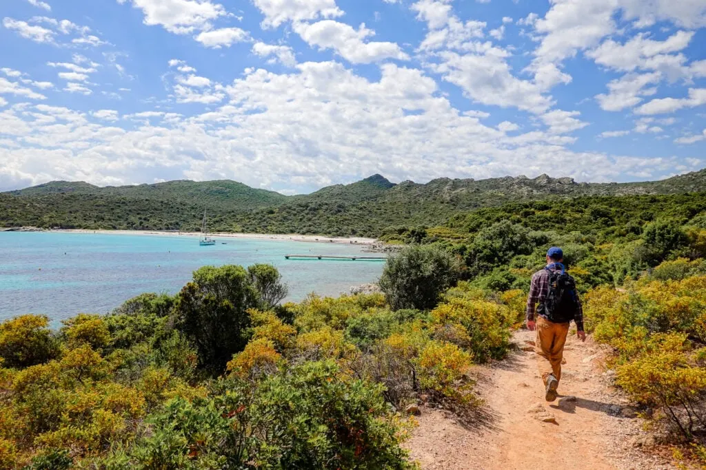
Punta di Curza
From Saleccia Beach to Lotu Beach, there is a roughly 4km track that wraps around Punta di Curza. Although Saleccia Beach and Lotu Beach are the main attractions, the point separating them is truly stunning.

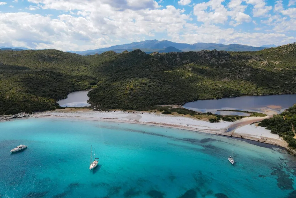
Lotu Beach (Plage du Lotu)
From Punta di Curza, you’ll soon spot Lotu Beach in the distance. Before reaching the beach, you’ll pass the beach’s jetty. We decided this would be a great vantage point to fly our drone!


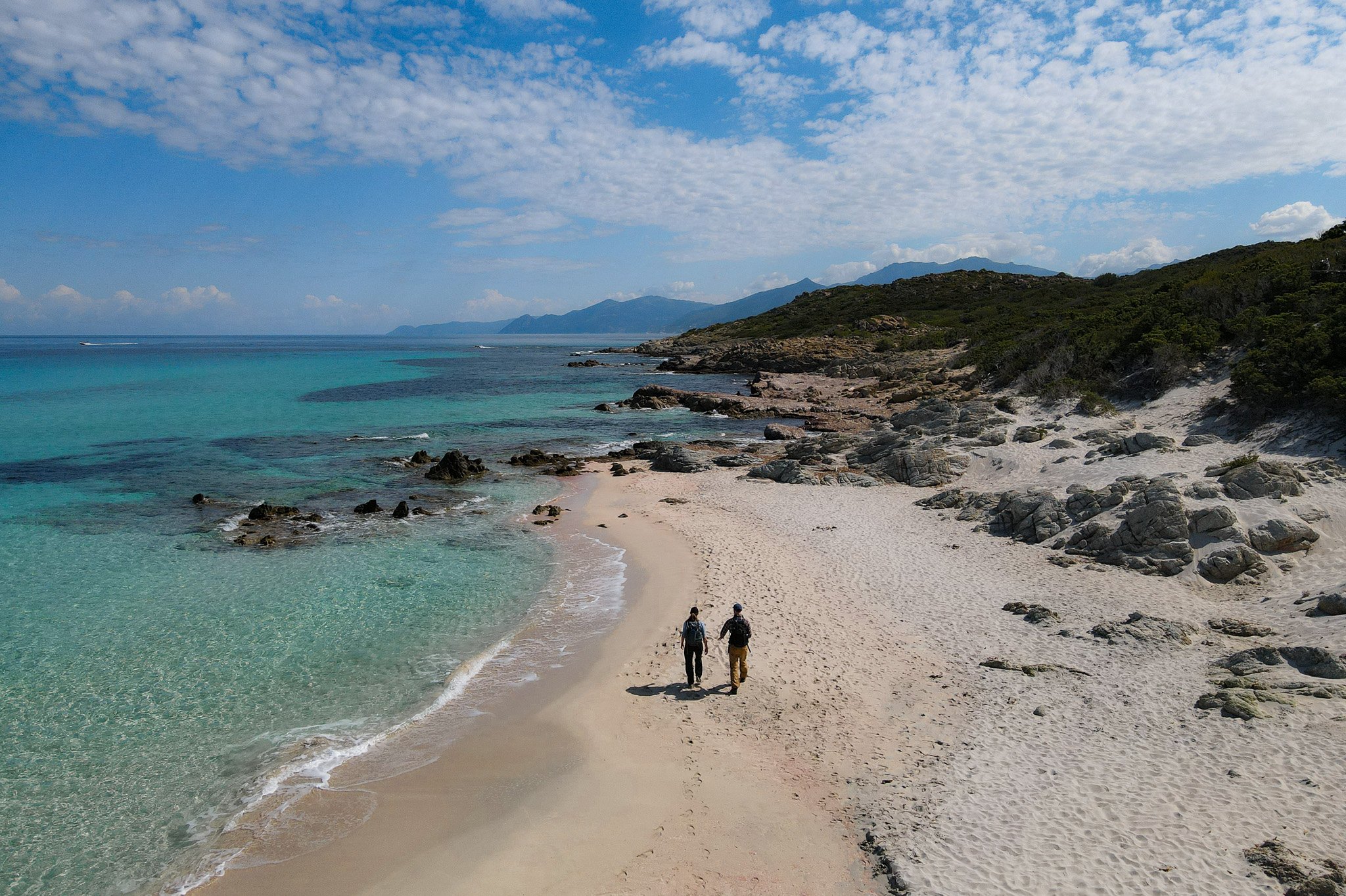
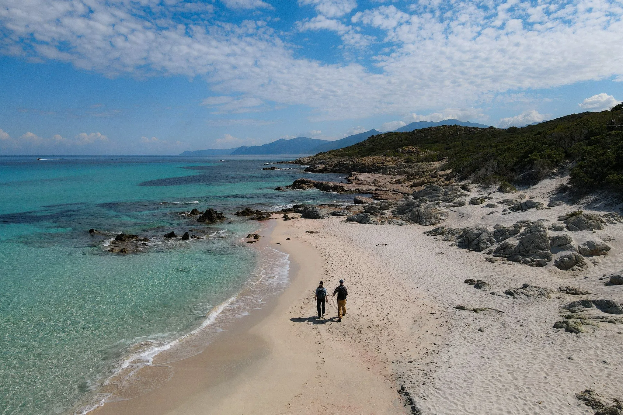
After capturing some aerial footage, we then made our way to Lotu Beach. Alongside Saleccia Beach, Lotu Beach is another breathtaking beach, featuring white sand and turquoise water. The beach is also well-known as a hangout for the local cows!

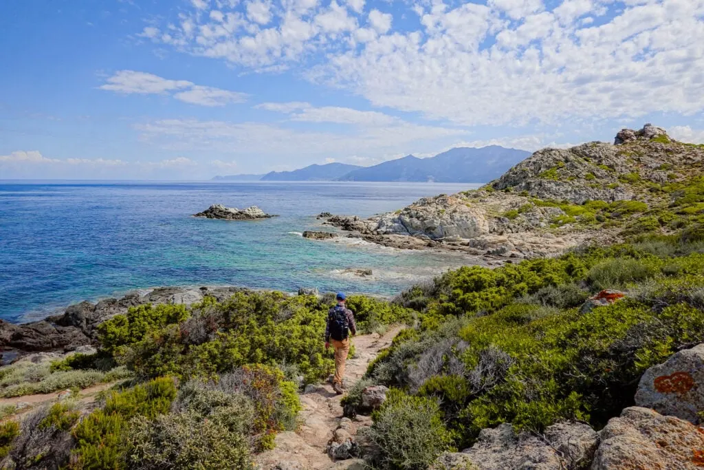
Punta Cavallata
After soaking in the picturesque views of the beach (and perhaps going for a swim), you’ll then continue along Sentier des Douaniers Saint-Florent. From Punta Cavallata, you’ll enjoy excellent views looking back at Lotu Beach.


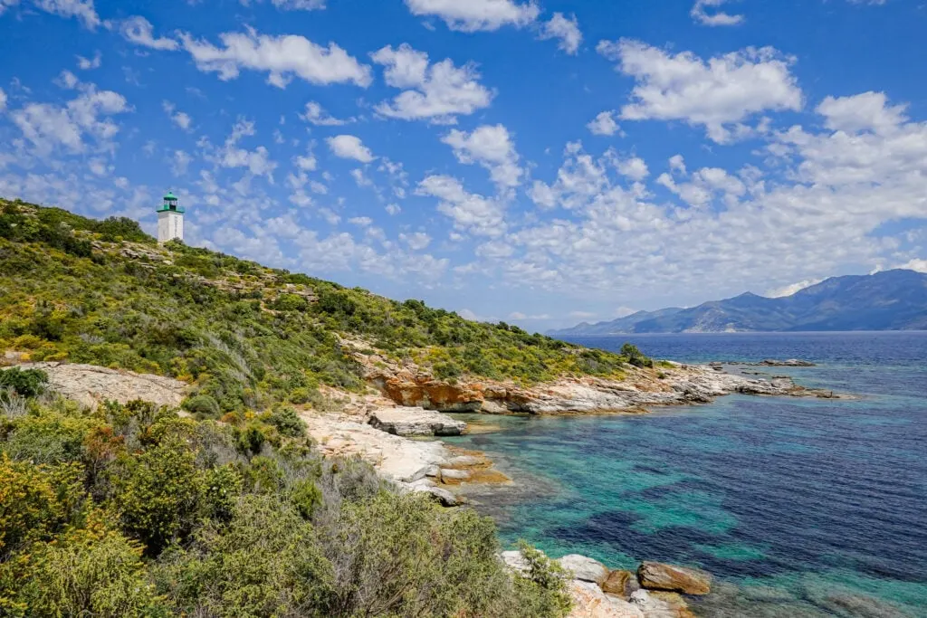
Mortella Lighthouse (Phare de la Mortella)
After walking along Punta Cavallata, you’ll soon climb a steep section at Punta Mortella. This part of the walk steers you by the enchanting Mortella Lighthouse.

Mortella Tower (Tour de Mortella)
After passing the green and white lighthouse, you’ll soon pass Mortella Tower. This Genoese fortification dates back to the 16th Century and formed part of their defence system to protect the island. Both the lighthouse and tower add diversity and history to this coastal walk, which is more known for its natural delights.

Fiume Santu Beach (Plage de Fiume Santu)
Once you pass the tower, you’ll soon reach Fiume Santu Beach. But not before a river crossing!
Essentially, to continue along Sentier des Douaniers Saint-Florent, you’ll need to wade across the river stream that opens at the northern end of Fiume Santu Beach. There is no way to avoid this.
If anything, the river crossing adds to the excitement of the coastal walk.
Once we crossed the river, we headed to the southern end of the beach to have lunch. This gave us the perfect opportunity to let our feet dry before continuing along the trail.


South of Fiume Santu Beach, you’ll wind along the coastline of Punta di Ceppu. Along this part of the walk, you’ll pass numerous miniature bays, surrounded by dense shrubland.

Fornali Beach (Plage de Fornali)
Eventually, you’ll reach Fornali Beach. As mentioned, there is a car park at this beach. So expect this beach to be busier than some of the beaches you’ve already passed.
Given the crowds, Beck and I didn’t spend long at Fornali Beach. We actually preferred exploring the quieter and smaller bays on either side of Fornali Beach.


Roya Beach (Plage de la Roya)
Between Fornali and Roya Beaches, you’ll enjoy a far-reaching view of Saint-Florent – the charming coastal town where your adventure began.

Soon enough, you’ll reach Roya Beach. Given its closeness to Saint-Florent, this is a very popular beach, especially with locals. It’s a long beach backed by parkland, so it’s normal to see lots of families picnicking in this area.
Roya Beach was even busier than Fornali Beach. So, Beck and I cracked on, heading back to Saint-Florent to complete the walk.
All in all, we really enjoyed this route option along Sentier des Douaniers Saint-Florent and highly recommend it!
Corsica Hiking Guides
- Corsica Hikes Guide: The 17 Best Day Hikes in Corsica
- Sentier des Douaniers Cap Corse – The Ultimate Walking Guide
- Sentier des Douaniers Saint-Florent – The Ultimate Walking Guide
- Pointe de la Revellata – The Complete Walking Guide
- Sentier du Facteur Girolata – The Ultimate Hiking Guide
- Sentier du Château Fort Piana – The Complete Walking Guide
- Calanques de Piana Hike via Sentier Muletier (Piana Mule Trail)
- Capo Rosso Hiking Trail – The Ultimate Guide
- Sentier des Crêtes Ajaccio to Monte Salario Walk – Visitor’s Guide
- Sentier des Douaniers Ajaccio – Pointe de la Parata to Petit Capo
- Capu di Muru (Capo di Muro) – The Complete Walking Guide
- Sentier du Littoral de Campomoro – Tour de Campomoro Walk
- Sentier Littoral des Bruzzi (Sentier des Bruzzi) – Visitor’s Guide
- Capo di Feno Bonifacio Walk (Includes Sentier de Fenu)
- Strada Vecia Madonetta – An Excellent Coastal Walk in Bonifacio
- Campu Rumanilu – Bonifacio Cliff Walk (The Ultimate Guide)
Discover Other Hikes in Corsica
Are you interested in doing other hikes in Corsica? Learn about all the best day hikes in Corsica.
Where to Stay Nearby
Saint-Florent is a gorgeous seaside town that’s the most convenient place to stay for walking the Sentier des Douaniers Saint-Florent. There are many excellent mid-range hotel accommodation options in the town. Below, we’ve handpicked the best mid-range options in Saint-Florent.
Leave a comment