
Schiahorn is an immense mountain in the Davos area of Switzerland. Reaching the mountain’s summit was one of the best hiking experiences that I’ve had in Switzerland.
In this guide, we’ll tell you everything you need to know about doing the Schiahorn Summit Hike.
Table of Contents
Schiahorn
Schiahorn is a Swiss mountain measuring approx. 2,708 metres above sea level. It’s located in the Parsenn (Parsennhütte) area of the Plessur Alps, a part of the Swiss Alps in the canton of Graubünden. The mountain is positioned on the western side of the Davos Valley overlooking the town of Davos.
With a little bit of planning (that I’ll help you with) and a lot of physically demanding work, you can also hike to the summit of the mountain!


Schiahorn Summit Hike
As the name suggests, the Schiahorn Summit Hike is the walk that ascends the peak of Schiahorn.
The most popular route option ascends the mountain from Schatzalp via Strelapass. This is the hiking option we’ll cover in more detail below.


Schiahorn Summit Hike Details
- Type: Out and Back
- Distance: 9.2km
- Time: 4.5–5.5 hours
- Accumulated elevation gain: 800m
- Difficulty: Hard
- Trailhead: Schatzalp
- Map: Komoot
To reach Schatzalp (trailhead), you have two options.
- Walk there from Davos.
- Take the Davos Platz (Schatzalpbahn) funicular there.
Given the significant elevation gain on this walk (approx. 755 metres), we recommend riding the Schatzalpbahn funicular from Davos Platz to Schatzalp. That way, you’ll save yourself from walking roughly 350 metres up from Davos to Schatzalp.
Check out the Schatzalp Funicular website for details regarding price and departure times.
Travel Insurance


Don’t leave for your trip without booking travel insurance. We all know accidents can happen and having Heymondo travel insurance could save you thousands of dollars if something goes wrong. Click the button below to receive a 5% discount!
Schiahorn Summit Hike Map
This map nicely illustrates the trails involved to complete the Schiahorn Summit Hike from Schatzalp (or even Davos).


Of course, for any mountain hikes, you’ll want to equip yourself with a proper map. Ideally, have a hard copy of a map to hand and/or digital GPS-guided directions on your phone.
It’s possible to pick up a free map at many cable car stations in Davos. Otherwise, simply download an offline version of a digital map on your navigation app of choice before you set out.
My Experience Doing This Hike
As discussed in my Davos Panoramaweg (Panorama Trail) blog post, I actually summited Schiahorn during an extended version of Davos Panoramaweg. This meant I didn’t have to hike up to Strelapass from Schatzalp. By doing the Davos Panoramaweg, I reached Strelapass, and ascended Schiahorn from there.
After descending the mountain, I then descended the trail back towards Schatzalp. Personally, I walked by Schatzalp and walked back to Davos Platz.
I’ve already detailed much of this hiking experience in the Davos Panoramaweg blog post. Because of that, I’ll simply detail my experience hiking the summit from Strelapass to Shiahorn below.


Summiting The Mountain
As mentioned, I arrived at Strelapass after walking along Davos Panoramaweg from Gotschna. If you’ve started the walk from Schatzalp, you’ll eventually reach Strelapass after a fairly gruelling, gradual ascent.
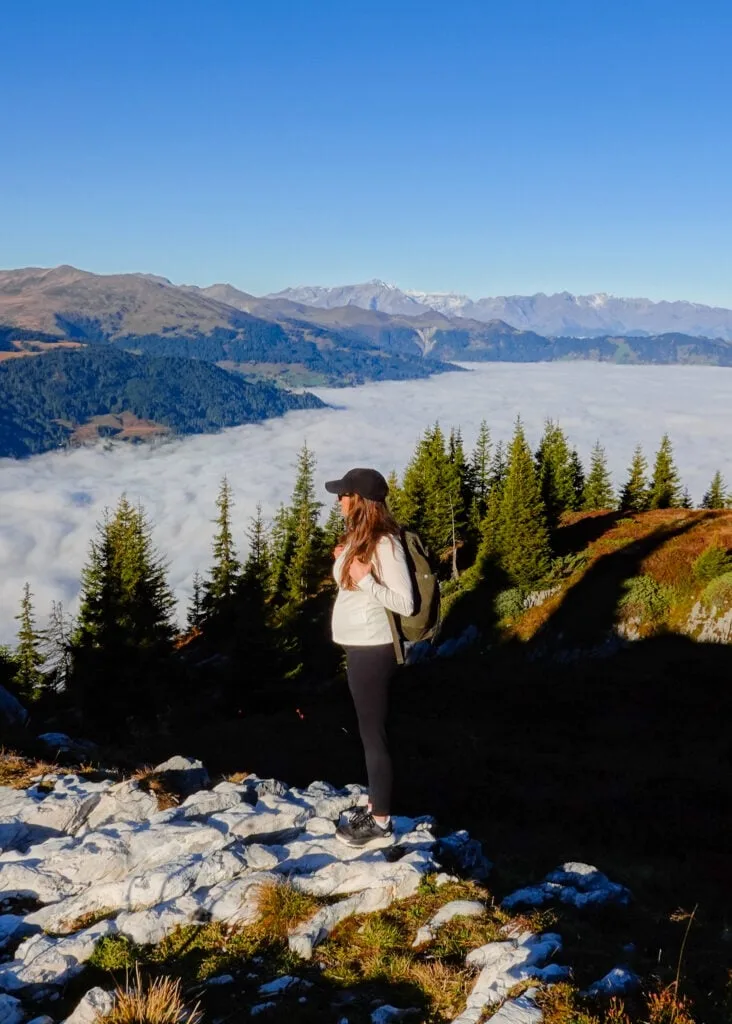
After taking in the superb west-facing views from the main viewpoint at Strelapass, it’s now time for the real hard work! There is no way to sugarcoat it – from Strelapass, the ascent to the summit of Schiahorn is steep and unrelenting.


Thankfully, during the physically challenging ascent, there are far-reaching, droolworthy views over the Davos Valley to distract you. In the distance, you’ll even have a view of Davos Lake.
The day I did this hike, I was blessed with sensational weather. In the middle of October, I was lucky to have clear skies and perfect visibility. If you choose to do this hike, I hope you have the same great weather!


After huffing and puffing my way up the mountain, sweating profusely on the way, I finally arrived at the peak of the mountain. From the summit, you’ll enjoy additional west-facing views of the Swiss Alps, which are otherwise obstructed lower down.
Having reached the peak of Schiahorn, I found myself a comfortable rock to sit on and threw down some lunch. To say I was eating with a view was an understatement!


After refuelling and soaking in the views, I decided it was time to fly the drone. In the photo below, you’ll see the tip of the east face of the mountain. If you want to see more drone footage from the area, feel free to watch our Davos Hiking YouTube video.


Descending the Mountain
After capturing aerial footage, it was time to descend the mountain. As you may expect, the descent is much quicker than the ascent. Soon enough, you’ll arrive back in Strelapass.
As mentioned, from Strelapass, I walked down to Davos. For others, you may simply retrace your steps, descending back to Schatzalp to get the funicular railway (Schatzalpbahn) back down to Davos Platz.
There is also a third option that we’ll quickly touch upon below.
Another Schiahorn Summit Hike Option
Another hiking option that involves summiting Shiahorn is shown in this AllTrails map. Essentially, you’ll walk between Schatzalp and Höhenweg via the Schiahorn summit.
As mentioned, to access Schatzalp, you can take the Davos Platz (Schatzalpbahn) funicular. Again, check out the Schatzalp Funicular website for details about costs and timetables.
To do the walk from Höhenweg, take the Parsenn Davos (Parsennbahn) funicular railway to Höhenweg, which is the mid-way stop en route to Weissfluhjoch. Check out the Davos Klosters Mountains website for rates and times for this funicular ride.
If you want to avoid an out and back walk or want to reduce some of the elevation loss (be kinder to your knees), this is a great trail alternative.


Other Hikes in Davos Klosters
- The 10 Best Davos Hikes: Your Davos Klosters Hiking Guide
- Joriseen Hike, Davos: How to Visit the Epic Joriseen Lakes
- Madrisa Hike to Ratschenhorn (Ratschenflue): The Ultimate Guide
- Rinerhorn Summit Hike, Davos: Everything You Need to Know
- Davos Panoramaweg (Davos Panorama Trail) Hiking Guide
- Schiahorn Summit Hike, Davos: The Ultimate Hiking Guide
- Hike (Not Bike) the ‘Alps Epic Trail Davos’ From Jakobshorn to Sertig
- Sertig Waterfall (Ducan Waterfall): The Complete Visitor’s Guide
- Davosersee Rundweg (AKA Lake Davos Trail) – Visitor’s Guide


Davos Accommodation
Most people hiking in this area will stay in Davos. Compared with Klosters, Davos offers many more accommodation options.
Klosters Accommodation
Despite Klosters having fewer accommodation options, it oozes a stronger rustic skiing-village vibe. So, if you’re after that classic Swiss village charm, you may want to stay in Klosters.
Where We Stayed: Solaria
Davos serves as a fantastic base for hiking the mountains surrounding it. Although the high street of Davos, which features many of its accommodation options, is fairly built-up and busy.
That’s why Beck and I chose to stay in Solaria, which is a quiet neighbouring town of Davos Dorf. Because we hired a car, we had more flexibility in choosing to stay in an area away from the town’s main hustle and bustle.
Car Hire


If you don’t have your own car, you should hire one using Discover Cars. Personally, we use Discover Cars and highly recommend them for finding your ideal car hire at an affordable price. Booking online is super easy and the free cancellation policy is great.
We had an excellent stay at Serviced Apartments by Solaria. Given how expensive Switzerland is, we wanted to stay in an apartment where we could do our own cooking. This self-catering apartment featured a well-equipped kitchen and spacious dining area with lovely mountain views. It really was a perfect base for our time spent hiking in Davos.
Serviced Apartments by Solaria


- Quieter area next to Davos Dorf
- Large private parking spaces
- Balconies provide stunning mountain views
Leave a comment