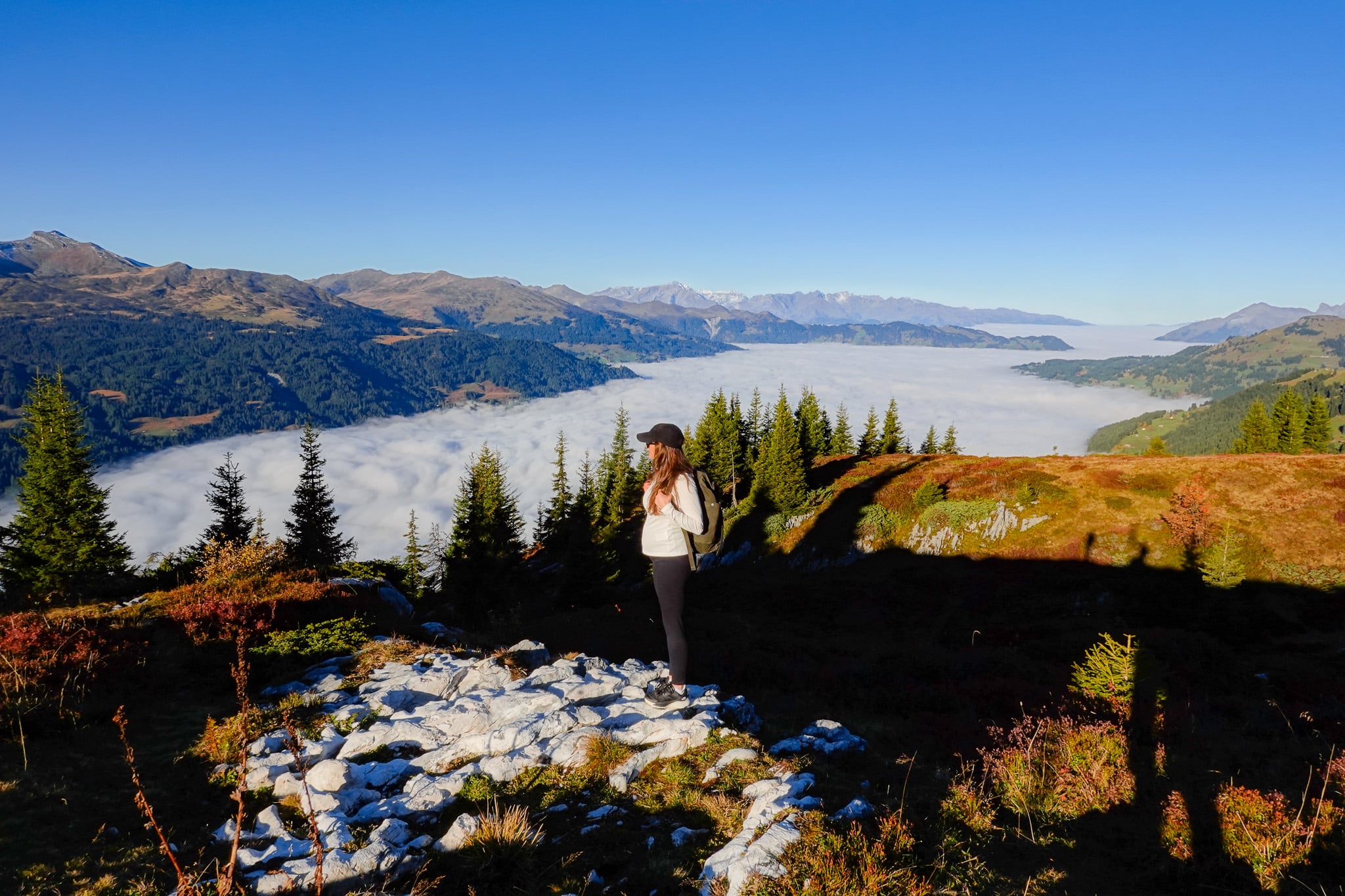
Davos is one of the most underrated hiking destinations in Switzerland. Located in eastern Switzerland, Davos is best known as a skiing destination. But, in the summer months, when most of the snow has melted, Davos becomes home to many breathtaking mountain hikes.
In this guide, we’ll run through the 10 best hikes in the Davos Klosters region. We’ll also detail everything you need to know about hiking in the area.
Table of Contents
Hiking in Davos Klosters
Given its reputation as a snow sports destination, you’ll find the hiking trails in Davos are generally quiet and void of crowds.
Certainly, compared with hikes in the more popular Swiss Alps destinations in the west (such as Interlaken, Zermatt, and the Jungfrau Region), hikes in Davos aren’t as busy, making them ideal for tranquil adventure.
The Davos Klosters region consists of a 700km network of signposted hiking trails. Undoubtedly, the area is a hiker’s playground, but without the reputation and resultant crowds.
Below, we’ll look at the 10 best hikes in the Davos Klosters area.


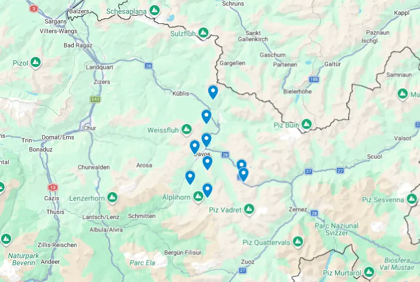
Davos Hikes Map
For your convenience, we’ve created an interactive map showing the 10 best hikes in the Davos Klosters area. The pin drop indicates the trailhead for the respective hike.

For Davos hiking maps, we generally used AllTrails. Please note that reception may be poor in the mountains. So make sure to download an offline version of the digital map before you set out.
Otherwise, you can’t go wrong with a traditional paper map. You’ll find free copies of this map (shown below) at most cable car and funicular railway stations in the Davos Klosters area. I picked up a free map on my first day hiking in the area. In addition, you can download an online version of this map from the Davos Klosters Mountains website.


Top 10 Best Hikes in Davos
Without further ado, let’s look at the best hikes in Davos, starting with the extraordinary Joriseen Hike.


1. Joriseen Hike
- Type: Loop
- Distance: 11km
- Time: 4–5 hours
- Accumulated elevation gain: 830m
- Difficulty: Hard
- Trailhead: Davos Wägerhus
- Parking: Parking Wägerhüttä (Google Maps)
- Map: AllTrails
The Joriseen Hike is the most popular hike in Davos Klosters. Renowned for its green-tinged Alpine lakes (known as Joriseen), the circular hike provides access to high mountain passes that offer the best views of them. The high mountain passes also provide impressive views of the surrounding Swiss Alps.
Undoubtedly, if there is one hike that you have to do in the Davos Klosters area, it’s this one!
Read more: Joriseen Hike, Davos – How to Visit the Epic Joriseen Lakes


2. Madrisa Hike to Ratschenhorn
- Type: Loop
- Distance: 12km
- Time: 5–6 hours
- Accumulated elevation gain: 870m
- Difficulty: Hard
- Trailhead: Madrisa Cable Car Station
- Map: AllTrails
Madrisa is a high-mountain area best known for its adventure park, Madrisa Land. In addition, Madrisa is short for the Madrisahorn, which is a landmark mountain in the Klosters area. There are many hikes in the Madrisa area that explore the mountains surrounding the Madrisahorn.
The Madrisa Hike to Ratschenhorn is one of the best hiking routes in the area. By doing this hike, you’ll hike to the peak of Ratschenhorn (AKA Ratschenflue). This summit features an awesome limestone-capped plateau and also offers mindblowing views of the Madrisahorn.
Read more: Madrisa Hike to Ratschenhorn (Ratschenflue) – The Ultimate Guide


3. Rinerhorn Summit Hike
- Type: Loop
- Distance: 7.6km
- Time: 3 hours
- Accumulated elevation gain: 515m
- Difficulty: Hard
- Trailhead: Rinerhorn Mountain Station (Jatzmeder)
- Map: AllTrails
Rinerhorn is one of the most well-known mountains in Davos. Located on the eastern side of Davos Valley, Rinerhorn reaches 2,528 metres above sea level. From the summit, you’ll enjoy spectacular views of the valley.
Even better than the views is the epic ridge south of the summit. From the summit, you’ll explore this ridge before seeing more of the area around Rinerhorn.
Read more: Rinerhorn Summit Hike, Davos – Everything You Need to Know


4. Davos Panoramaweg (Davos Panorama Trail)
- Type: One-way
- Distance: 14.3km
- Time: 5.5–6.5 hours
- Accumulated elevation gain: 425m
- Difficulty: Hard
- Trailhead: Gotschna Cable Car Station or Schatzalp Funicular Station
- Map: AllTrails
The Davos Panoramaweg (Davos Panorama Trail) is one of the most quintessential hikes in the area. The high traverse lies west of the Davos Valley, offering mouth watering views of the mountains overlooking Davos.
Despite the 11km Davos Panoramaweg having defined start and end points, there are still several route options involving the trail. Cable car and funicular railway access along different sections of the trail, as well as near the trail, enables these variations.
So, depending on your fitness level, experience, and mood, you can choose an easy, moderate, or challenging route option.
Read more: Davos Panoramaweg (Davos Panorama Trail) Hiking Guide


5. Schiahorn Summit Hike
- Type: Out and Back
- Distance: 9.2km
- Time: 4.5–5.5 hours
- Accumulated elevation gain: 800m
- Difficulty: Hard
- Trailhead: Schatzalp
- Map: Komoot
Measuring 2,708 metres above sea level, Schiahorn overlooks the town of Davos from the western side of the valley. From the summit of Schiahorn, you’ll enjoy breathtaking views of Davos Valley and beyond. The steep hike up Schaihorn is physically demanding, but the superb views from its peak make the effort worthwhile.
Read more: Schiahorn Summit Hike, Davos – The Ultimate Hiking Guide


6. Jakobshorn Hike to Sertig
- Type: One-way
- Distance: 7km
- Time: 3 hours
- Accumulated elevation gain: 45m
- Difficulty: Easy
- Trailhead: Jakobshorn Mountain Station
- Map: AllTrails
Alongside Rinerhorn, Jakobshorn is another one of the most well-known mountains in Davos Valley. Starting from the peak of Jakobshorn, you’ll walk down a mountain bike trail (called ‘Alps Epic Trail Davos’) to the charming village of Sertig. Along the way, you’ll pass a lesser-known yet mesmerising turquoise lake called Stadlersee.
Read more: Hike (Not Bike) the ‘Alps Epic Trail Davos’ From Jakobshorn to Sertig


7. Jakobshorn to Sertig via Jatzhorn
- Type: One-way
- Distance: 8km
- Time: 3–3.5 hours
- Accumulated elevation gain: 180m
- Difficulty: Hard
- Trailhead: Jakobshorn Mountain Station
- Map: Outdooractive
It’s worth mentioning that there is an alternate hike between Jakobshorn and Sertig. This is the ridge hike along Jatzhorn and Witihureli, which runs parallel to the ‘Alps Epic Trail Davos’. Personally, I didn’t hike along this ridge and had serious FOMO because of it.
Admittedly, the ridge hike between Jakobshorn and Sertig via Jatzhorn and Witihureli looks absolutely epic. But, if you’re after an easier stroll, consider hiking from Jakobshorn to Sertig via the ‘Alps Epic Trail Davos’.


8. Fluela Schwarzhorn
- Type: Loop
- Distance: 11.6km
- Time: 5.5–6 hours
- Accumulated elevation gain: 890m
- Difficulty: Very hard
- Trailhead: Fluela Pass
- Map: AllTrails
At 3,146 metres above sea level, Fluela Schwarzhorn is the highest point in Davos Klosters. Alongside the Jakobshorn to Sertig ridge hike via Jatzhorn, this was the other hike that Beck and I sadly didn’t get a chance to do. We simply ran out of time.
Certainly, though, if you have a bit more time than we did, add this hike to your Davos hikes itinerary. We’ve heard this route serves as a fantastic sunrise hike.


9. Sertig Waterfall Hike
- Type: Out & Back
- Distance: 3km
- Time: 1 hour
- Accumulated elevation gain: 130m
- Difficulty: Very easy
- Trailhead: Walserhuus Sertig Car Park
- Map: AllTrails
Sertig Waterfall (AKA Ducan Waterfall) is a lesser-known multi-tier waterfall found in Sertig Valley, near the village of Sertig. This is one of the easiest hikes in Davos Klosters. You’ll follow a short (and mostly) flat trail through the picturesque valley, eventually arriving at the stunning three-tier waterfall.
Read more: Sertig Waterfall (Ducan Waterfall) – The Complete Visitor’s Guide


10. Davosersee Rundweg (Lake Davos Trail)
- Type: Loop
- Distance: 4km
- Time: 1 hour
- Accumulated elevation gain: 120m
- Difficulty: Very easy
- Trailhead: Lake Davos Car Park
- Map: AllTrails
Davosersee (Davos Lake) is one of the most well-known natural attractions in the area. There is a serene track that loops around the lake. For another easy hiking option in Davos, we highly recommend doing the Davosersee Rundweg (Davos Lake Trail).
Read more: Davosersee Rundweg (AKA Lake Davos Trail) – Visitor’s Guide


General Tips For Hiking in Davos Klosters
Below are the most useful things to know about hiking in Davos Klosters.
- Best time of year to hike: between mid-June and mid-October, you can generally complete all of the mountain hikes listed, as most of the snow on the tracks has melted. Outside this period, the hikes may be inaccessible due to snow, and the cable car and funicular railway networks are not in operation for hiking. Of course, they operate during the snow season for our skiers and snowboarders!
- Be prepared: have the right gear and check the weather before you set off. After all, you’re in the mountains!
Tips For Planning Your Hiking Trip
- Public transport: Davos Klosters has a decent public transport system, with buses and trains connecting the main hubs. This allows decent access to most of the walks listed in this guide. Download the SBB Mobile app to help plan your journey.
- Cable car and funicular railway: Davos Klosters also offers access to the mountains via cable cars and funiculars. You’ll definitely utilise these services to access trailheads for many of the mountain hikes listed in this guide. The Davos Klosters Mountains website details costs and departure times for most of these services. However, some services are run by other private companies, such as the Schatzalp funicular. These companies also have websites where you can check costs and timetables.
- Davos Klosters Premium Card: by booking at least one night’s accommodation in Davos or Klosters, you’ll gain access to the ‘Davos Klosters Premium Card’. This card offers significant discounts on public transport, including buses, trains, cable cars, and funicular railways. You’ll receive a physical card from your accommodation upon arrival. Keep it on you to save money on public transport.
- Paying for parking: most, if not all, parking in Davos Klosters is paid parking. Download the EasyPark app to conveniently pay for parking on your smartphone.


How to Get to Hikes in Davos
As mentioned, most hikes in Davos are easily accessible by public transport (bus/train) or by driving. You may then need to ride a cable car or the funicular railway to access the trailhead of a hike in the mountains.
For most of the hikes in this guide, we have published a separate blog post with details about how to access them.
For most hikes that we did in Davos, we drove to the trailhead or the cable car/funicular railway station. We flew to Zurich Airport and hired a car. From there, we drove to Davos and used the car to help us access many of the hikes in the area.
Car Hire


If you don’t have your own car, you should hire one using Discover Cars. Personally, we use Discover Cars and highly recommend them for finding your ideal car hire at an affordable price. Booking online is super easy and the free cancellation policy is great.
To find out more about renting a car with Discover Cars, read our Discover Cars review and Discover Cars Insurance review.
Accommodation
There are plenty of fantastic accommodation options in both Davos and Klosters. Despite having fewer options, Klosters oozes a more rustic Swiss-village vibe. So, if you’re after a traditional stay, you may want to stay in Klosters.
Davos offers a wider range of accommodation with more budget-friendly options. We chose to stay in the Davos area, primarily because Beck was working at an event in Davos town centre. That said, even if this wasn’t the case, we would likely still have stayed in the Davos area rather than Klosters, as it offered a better base for our hiking trip.
Specifically, Beck and I chose to stay in Solaria, which is a quiet neighbouring town of Davos Dorf.
Where We Stayed: Solaria
We had a lovely stay at Serviced Apartments by Solaria. Given how expensive Switzerland is, we stayed in a self-catering apartment to dodge expensive dining out. This apartment had a well-equipped kitchen and a spacious dining area with mountain views. It was a perfect base for our time doing hikes in the Davos Klosters region.
Serviced Apartments by Solaria


- Quieter area neighbouring Davos Dorf
- Large private parking area
- Balconies with mountain views
Travel Insurance For Hikes in Davos
It goes without saying that having travel insurance is a no-brainer. Of course, the need for travel insurance increases if you plan on going on any outdoor adventures, such as high-altitude trekking.
Most of the hikes in this guide (except Fluela Schwarzhorn) stay under 3,000 metres above sea level. When considering travel insurance, ensure the provider not only covers hiking, but covers hiking at the necessary altitude.
For instance, at the time of writing, Heymondo covers hiking up to 3,000 metres as part of their standard cover. But if you want to hike up Fluela Schwarzhorn, you’ll need to add Adventure Sports Cover.
Heymondo is one of the best budget travel insurance providers on the market. They provide comprehensive travel and medical insurance that won’t break the bank. Whether it’s single trip insurance, annual multi-trip insurance or long stay insurance, Heymondo offers affordable travel and medical insurance to suit all of your needs. Personally, we use Heymondo travel insurance and highly recommend it. To find out more about Heymondo travel and medical insurance, read our Heymondo travel insurance review.
Travel Insurance


Don’t leave for your trip without booking travel insurance. We all know accidents can happen and having Heymondo travel insurance could save you thousands of dollars if something goes wrong. Click the button below to receive a 5% discount!
Best Davos Hikes Guidebooks
Personally, we didn’t use any specific guidebooks when planning our Davos Klosters hiking trip. The main guidebook that we came across when planning our trip was Best Hiking in Switzerland in the Valais, Bernese Alps, the Engadine and Davos: Over 100 Hikes in the Spectacular Swiss Alps by Diane Greer.


Leave a comment