Rinerhorn is one of the most well-known mountains in the Davos Klosters region of Switzerland. It’s primarily popular as a winter sports area for skiing and snowboarding.
However, in the summer and shoulder months, the mountain serves as an underrated hiking destination. The Rinerhorn Summit Hike is a lesser-known yet spectacular hike in Switzerland that I did and highly recommend.
In this guide, I’ll tell you everything you need to know about doing this hike.
Table of Contents
Rinerhorn
Rinerhorn is a mountain on the eastern side of the Davos Valley, rising to 2,528 metres above sea level. As mentioned, it’s a popular destination for snow sports enthusiasts. But, in the warmer months, when most of the snow has melted, the mountain turns into a hiker’s playground. Yet, hikers haven’t really cottoned on to this, yet!
I completed the Rinerhorn Summit Hike around sunrise in mid-October during a 5 day trip to Davos. It was one of my favourite hiking experiences in the area.
Below, let’s look at the main trail specs for this hike.


Rinerhorn Summit Hike Details
- Type: Loop
- Distance: 7.6km
- Time: 3 hours
- Accumulated elevation gain: 515m
- Difficulty: Hard
- Trailhead: Rinerhorn Mountain Station (Jatzmeder)
- Map: AllTrails


Rinerhorn Summit Hike Map
This map nicely illustrates the circular route of the hike.


Of course, before doing this hike, make sure to get your hands on a map (they’re usually available for free at cable car stations in the Davos Klosters area). Otherwise, download an offline digital map as reception in the mountains can be poor. For instance, download this AllTrails map.
Personally, I grabbed a free map and downloaded a digital map with GPS directions (AllTrails).
Travel Insurance


Don’t leave for your trip without booking travel insurance. We all know accidents can happen and having Heymondo travel insurance could save you thousands of dollars if something goes wrong. Click the button below to receive a 5% discount!
How to Get to Davos Glaris
To do this hike, you’ll need to take the Rinerhornbahn cable car from Davos Glaris to the Rinerhorn Mountain Station (Jatzmeder). There are two main ways to reach Davos Glaris.
- Catch a bus there from Davos Platz. Use the SBB Mobile app to help plan your journey.
- Drive there and park at the large Davos Glaris cable car station car park. Use the EasyPark app to pay for parking.
Beck and I hired a car for our trip to Davos. Unfortunately, Beck was working at an event in Davos, which meant she couldn’t join me for the hike. So, I drove solo to the Davos Glaris cable car station.
Car Hire


If you don’t have your own car, you should hire one using Discover Cars. Personally, we use Discover Cars and highly recommend them for finding your ideal car hire at an affordable price. Booking online is super easy and the free cancellation policy is great.
To find out more about renting a car with Discover Cars, read our Discover Cars review and Discover Cars Insurance review.
Rinerhorn Cable Car (Gondola)
Once you’ve arrived at the Davos Glaris cable car station, it’s time to ride the Rinerhornbahn (Glaris-Jatzmeder service). This cable car (gondola) takes you from Davos Glaris up to the Rinerhorn Mountain Station (Jatzmeder).
Head to the Davos Klosters Mountains website for more details about costs and departure times.
Personally, I paid CHF 13, which was a discounted price for having the ‘Premium Card’. At the time of visiting, this card was given to visitors staying in Davos, offering significant discounts on public transport. I caught the first ride of the day at 8:30am. From memory, the cable car ride took around 10 minutes.
Rinerhorn Summit Hike Highlights
From the Rinerhorn Mountain Station, the Rinerhorn Summit Hike begins! Below, I won’t put you through a tedious trail description. Rather, I’ll point out highlights of the walk, briefly share my experience and show you some photos along the route.


From the Rinerhorn Mountain Station, you’ll commence a steep ascent. When I arrived at the station, the sun hadn’t yet hit the eastern side of Davos Valley. To warm myself up, I cracked on with the hike in search of sunshine. It wasn’t until I reached Hubel that I reached that joyous warmth of sunlight.
Hubel
During the initial stages of the walk from the mountain station to Hubel, you’ll enjoy impressive views of Davos Valley.
From Hubel, you’ll commence a steeper ascent towards the summit of Rinerhorn.


Rinerhorn Summit
The trail from Hubel to Rinherhorn is considered a High Alpine trail. I completed the hike in the middle of October and found the track to be snowy and icy in sections as I approached the summit.
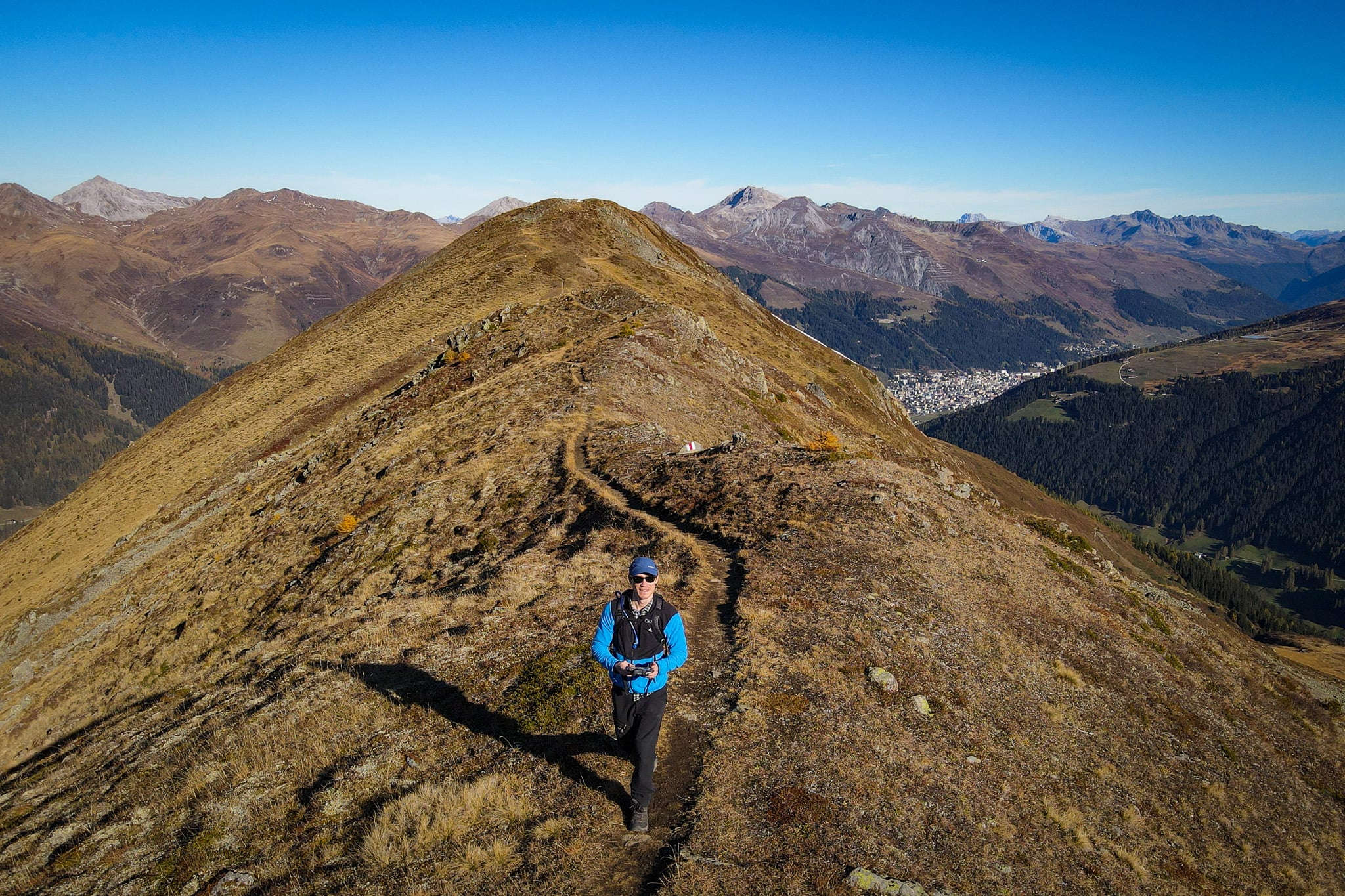
Eventually, I reached the summit. Without a doubt, you can enjoy some of the best views of the Davos Klosters region from the peak of Rinerhorn. Not only will you enjoy far-reaching views towards Davos, but you’ll also have a panoramic viewpoint of this part of the Swiss Alps.


Even better than the views is the epic ridge located between Rinerhorn and Leidbackhorn (2,908 metres). From the summit of Rinerhorn, you’ll then descend its southern face, walking along this gnarly ridge.


Exploring this ridge just south of Rinerhorn is one of the best sections of this hike. Soon enough, you’ll reach the end of the relatively short ridge. At the southern end of the ridge, you’ll enjoy superb views of Leidbackhorn.


Marchhureli
After that, the trail veers towards Marchhureli (2, 577 metres). Between the southern ridge of Rinerhorn and Marchhureli, the trail is incredibly undulating as you wind around a rocky terrain.
With Leidbackhorn looming large to your left, you’ll eventually pass the peak of Marchhureli. Admittedly, this isn’t a significant point of interest. You’ll simply pass by Marchhureli, then begin your descent along Nullischgratweg.


Nullischgratweg
The final section of the Rinerhorn Summit Hike is the Nullischgratweg trail. The trail explores an area of Rinerhorn called Nullisch Grat. The highlights of this section of the walk are a quaint cascade and gorgeous forested terrain.
The Nullischgratweg trail will eventually lead you back to the Rinerhorn Mountain Station. Hike complete!


Other Hikes in Davos Klosters
- The 10 Best Davos Hikes: Your Davos Klosters Hiking Guide
- Joriseen Hike, Davos: How to Visit the Epic Joriseen Lakes
- Madrisa Hike to Ratschenhorn (Ratschenflue): The Ultimate Guide
- Rinerhorn Summit Hike, Davos: Everything You Need to Know
- Davos Panoramaweg (Davos Panorama Trail) Hiking Guide
- Schiahorn Summit Hike, Davos: The Ultimate Hiking Guide
- Hike (Not Bike) the ‘Alps Epic Trail Davos’ From Jakobshorn to Sertig
- Sertig Waterfall (Ducan Waterfall): The Complete Visitor’s Guide
- Davosersee Rundweg (AKA Lake Davos Trail) – Visitor’s Guide


Where to Stay Nearby
The best accommodation options nearby are in Davos (either Davos Dorf or Davos Platz). Sure, the most convenient place to stay for doing the Rinerhorn Summit Hike is in Davos Glaris. But you’ll find many more accommodation options around the main hub of Davos.
Where We Stayed: Solaria
Beck and I chose to stay in Solaria, which is a charming neighbouring town of Davos Dorf. Because we had a car, we had more flexibility to choose a quieter area away from the hustle and bustle of Davos.
We had a terrific stay at Serviced Apartments by Solaria. Given how expensive Switzerland is, we stayed in an apartment so that we could do our own cooking. This self-catering apartment had a decent kitchen and spacious dining area with mountain views. This apartment really was a perfect base for hiking in Davos.
Serviced Apartments by Solaria


- Quieter area near Davos Dorf
- Private parking available
- Balconies with mountain views
Leave a comment