The NC500 route in Scotland boasts scenic driving, beautiful wildlife, stunning beaches and gorgeous mountain landscapes. Since its launch in 2015, the NC500 has become increasingly popular. This guide details 18 excellent NC500 hikes, as well as other must-do walks that we didn’t have time to do. Essentially, all of the best hikes along the NC500 are detailed in this in-depth guide.
Table of Contents
18 Excellent NC500 Hikes
Most visitors to the NC500 are focused on the road trip itself, rather than hiking along the route. However, the NC500 provides a myriad of stellar walks. Even if you just want to choose a few walks for your NC500 adventure, you can use this guide to find a hike to your liking.
For those hiking enthusiasts, there are enough walks along the NC500 to keep you busy for 2–3 weeks. Better yet, because the NC500 attracts non-hiking tourists, the trails along the route are undeservedly quiet. So, you’ll have plenty of non-crowded trails to enjoy, even in the middle of summer!
For sure, the 18 NC500 trails detailed below are a great mix of challenging mountain trails, mixed-difficulty waterfall walks and simpler routes to natural attractions or castles. We hope you enjoy some or all of these fantastic hiking trails along the NC500.
Travel Insurance


Don’t leave for your trip without booking travel insurance. We all know accidents can happen and having Heymondo travel insurance could save you thousands of dollars if something goes wrong. Click the button below to receive a 5% discount!
1. Rogie Falls
- Type: Loop
- Distance: 2km
- Time: 0.75 hours
- Accumulated elevation gain: 55m
- Difficulty: Very Easy
- Trailhead: Rogie Falls Car Park
If you’re completing the NC500 in a clockwise direction from Inverness, Rogie Falls will be your first hike to enjoy. This short loop track is actually one of the best hikes along the NC500. Not only is Rogie Falls one of the best waterfalls along the NC500, but you’ll have the pleasure of watching the theatrical struggle of Atlantic salmon swimming upstream (if you visit between July and September)! Make sure to watch our NC500 YouTube production to see the salmon in action.
Read more: Rogie Falls – A Beautiful Waterfall on Scotland’s NC500


2. Sgùrr a’ Chaorachain
- Type: Out & Back
- Distance: 7km
- Time: 2–2.5 hours
- Accumulated elevation gain: 390m
- Difficulty: Moderate
- Trailhead: Bealach na Bà Viewpoint
The relatively short out and back Sgùrr a’ Chaorachain route is a solid warm-up hike before you tackle the monster mountain trails in Torridon. From the Bealach na Bà Viewpoint, you’ll follow a wide track that heads towards the TV transmitter mast. The steady incline on mostly even terrain provides a great opportunity for speed hiking. Sweeping views of Skye Cuillin and the Isle of Rum enjoyed at the trailhead viewpoint are amplified as you begin to gain elevation.
Despite the TV transmitter mast being 773 metres above sea level, this is not the summit of the mountain! In fact, the true summit is Sgùrr a Chaorachain, which is categorised as a Corbett, and is still a couple of kilometres away!
To get to the Corbett, you’ll follow a pathless landscape that initially descends and passes through some fairly boggy terrain. Some of the best viewpoints are along this section of the trail, between the TV transmitter and Sgùrr a Chaorachain.
You’ll then have some sharper descents and climbs to navigate before reaching the true summit, marked by a cairn. From Sgùrr a Chaorachain, the views of the surrounding ridges are absolutely superb! To complete the route, you’ll simply retrace your steps.
Read more: Sgùrr a Chaorachain Hike – The Best Of Beautiful Bealach Na Ba


3. Sands, Applecross
- Type: One & Back
- Distance: 2km
- Time: 0.5 hours
- Accumulated elevation gain: 20m
- Difficulty: Very Easy
- Trailhead: Sands, Applecross Parking
Not to be confused with the main Applecross Beach, this short out and back beach trail explores the incredible white sands and turquoise waters of Sands, Applecross. Don’t get us wrong, you should visit Applecross Beach. But, we believe Sands, Applecross is an even better option. It’s much quieter and lesser-known. Plus, the white sand is absolutely superb, compared to the sandless Applecross Beach.
Some might argue that the Sands, Applecross trail is barely a hike. Well, that might be the case; but, the 2km out and back trail is a stellar short walk option to explore one of the best beaches on the NC500 route.
Whether you explore just Applecross Beach, the Sands, Applecross trail, or both, driving around the Applecross area is marvellous.
Read more: Applecross Scotland – The Complete NC500 Guide


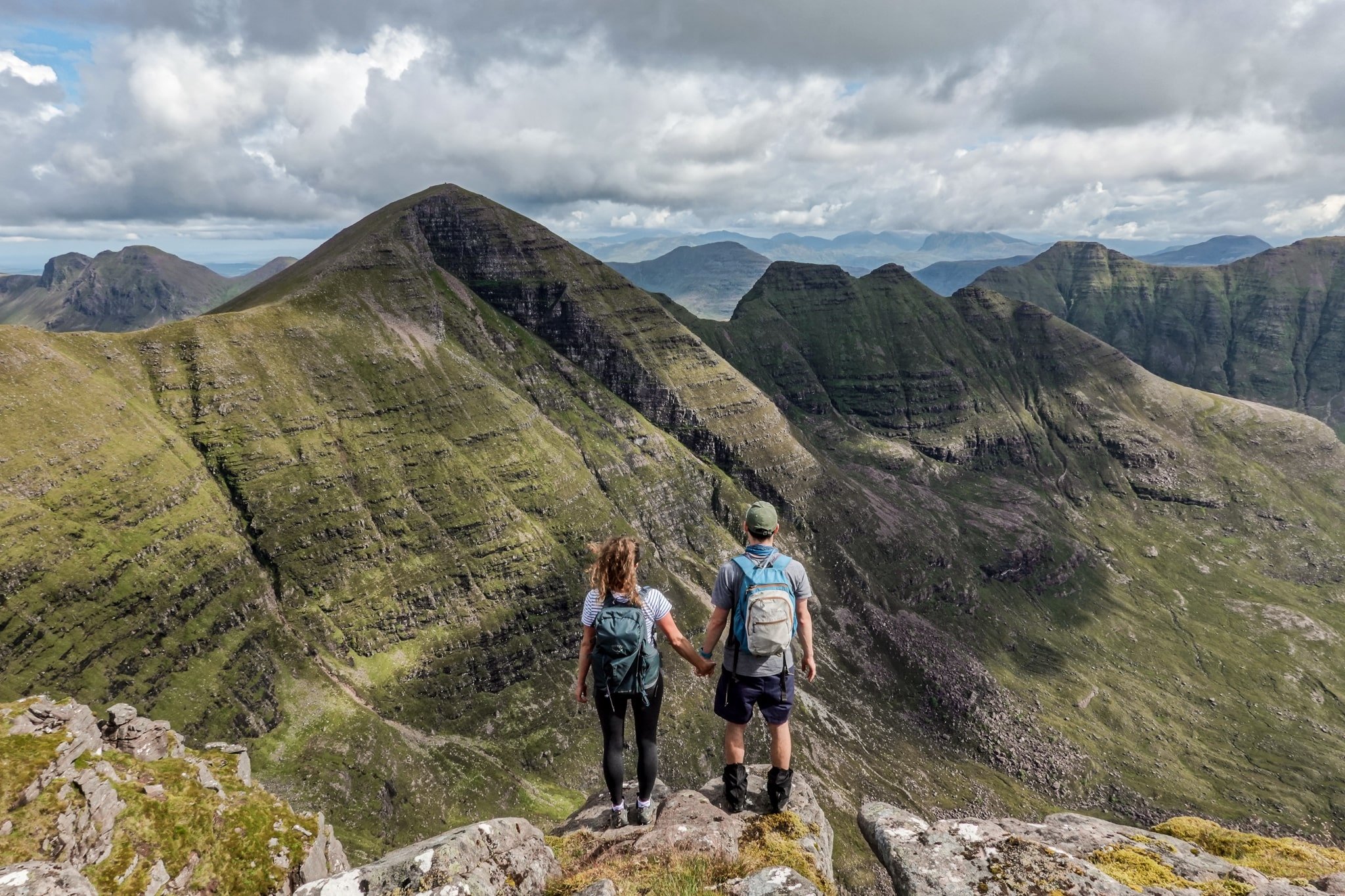
4. Beinn Alligin
- Type: Loop
- Distance: 11.5km
- Time: 5.5–6.5 hours
- Accumulated elevation gain: 1,240m
- Difficulty: Hard
- Trailhead: Beinn Alligin Car Park
The Beinn Alligin trail was possibly our favourite of the entire NC500 route. After taking in a lovely waterfall at the beginning of the trail, if completing in an anti-clockwise direction, you’ll soon be following the east bank of the river, passing many gorgeous waterfalls as you slowly begin to ascend.
FYI – we chose to hike Beinn Alligin atypically in an anti-clockwise direction, because the afternoon forecast looked poor, and so we wanted to complete the more intense scrambling on the southeast ridge earlier in the day.
Arriving at the first of the Beinn Alligin horns signals your first scramble of the day. Honestly speaking, compared to some of the other scrambling we have done previously in the West Highlands, this was only mild.
From there, you’ll have a couple more of the Horns to navigate and scramble as you follow some epic ridgelines. The steep peak of Sgùrr Mhòr (1,109m) marks your first Munro of the day and provides unbelievable views.
Following Sgùrr Mòr, you’ll reach Fasreidhnean Beinn Alligin – a minor top (869m) marked by a cairn, which provides more stellar views. You’ll then descend Fasreidhnean Beinn Alligin, passing some spectacular cliffs and views of endless lochs.
Soon enough, you’ll reach the second Munro of the trail – Tom na Gruagaich (922m), which has possibly the best views of the entire route. This Munro provides particularly exceptional views of the Beinn Alligin range!
From Tom na Gruagaich, you’ll begin the gruelling descent that zig-zags back towards the car park.
Beinn Alligin vs. the Other Torridon ‘Big Three’
Needless to say, Beinn Alligin was an absolutely crackin’ trail! Also, it has less hardcore scrambling than Beinn Eighe (Western Summits) and Liathach. So, if you’re new to scrambling, Beinn Alligin may be your preferred option when hiking one of the Torridon ‘Big Three’.
Read more: Beinn Alligin – The Ultimate Guide To This Incredible Torridon Hike


5. Beinn Eighe NNR Mountain Trail
- Type: Loop
- Distance: 6.5km
- Time: 2.75 hours
- Accumulated elevation gain: 530m
- Difficulty: Moderate
- Trailhead: Coille na Glas Leitre Trails Car Park
The Beinn Eighe NNR Mountain Trail is an ideal hiking option near Torridon (Kinlochewe) if you’re not quite prepared to tackle any one of the Torridon ‘Big Three’. Plus, this trail is Britain’s alleged only waymarked mountain trail – so, that has to be bucket list-worthy!
From Loch Maree, you’ll essentially head into the opposing forest, slowly but gradually climbing the waymarked route. The path is easy to follow, so you can simply enjoy the increasingly sweeping views of Loch Maree and the pure white quartzite crags surrounding you.
Eventually, the trail flattens as you reach the highest peak of the trail, signalled by a large cairn. Here, you’ll have superb views of the western summits of Beinn Eighe. Afterwards, you’ll pass Lunar Loch, before veering towards the side of a gorge. The trail then descends, connecting with the Woodland Trail back to Loch Maree.
Admittedly, we were disappointed not to be able to hike Beinn Eighe (Western Summits) due to poor weather conditions. But, as a consolation, the Beinn Eighe NNR Mountain Trail was a shorter route option that we could squeeze into our itinerary after hiking Beinn Alligin. In fact, this trail provides astonishing views of the Beinn Eighe Western Summits.
Read more: How To Hike Beinn Eighe National Nature Reserve Mountain Trail


6. Lady Fowler’s Fern Walk
- Type: Loop
- Distance: 1.5km
- Time: 0.5 hours
- Accumulated elevation gain: 50m
- Difficulty: Very Easy
- Trailhead: The Falls of Measach Car Park
Once you’ve completed as many of the Torridon-based NC500 hikes, it’s time to head further north. En route to Ullapool and beyond, we highly recommend stopping off to complete Lady Fowler’s Fern Walk loop trail. Located in the serene Corrieshalloch Gorge NNR, the Lady Fowler’s Fern Walk is a short and easy route, which includes extraordinary views of the Falls of Measach.
Unfortunately, when we visited in August 2021, the suspension bridge was closed. So, we didn’t get to experience the amazing views of the Falls of Measach that we had heard so much about. Honestly speaking, without accessing the suspension bridge and views of the waterfall, this walk was fairly tame and would be worth skipping. But don’t worry, as of late 2021, the suspension bridge appears to be back open! So with that in mind, we highly recommend doing this walk.


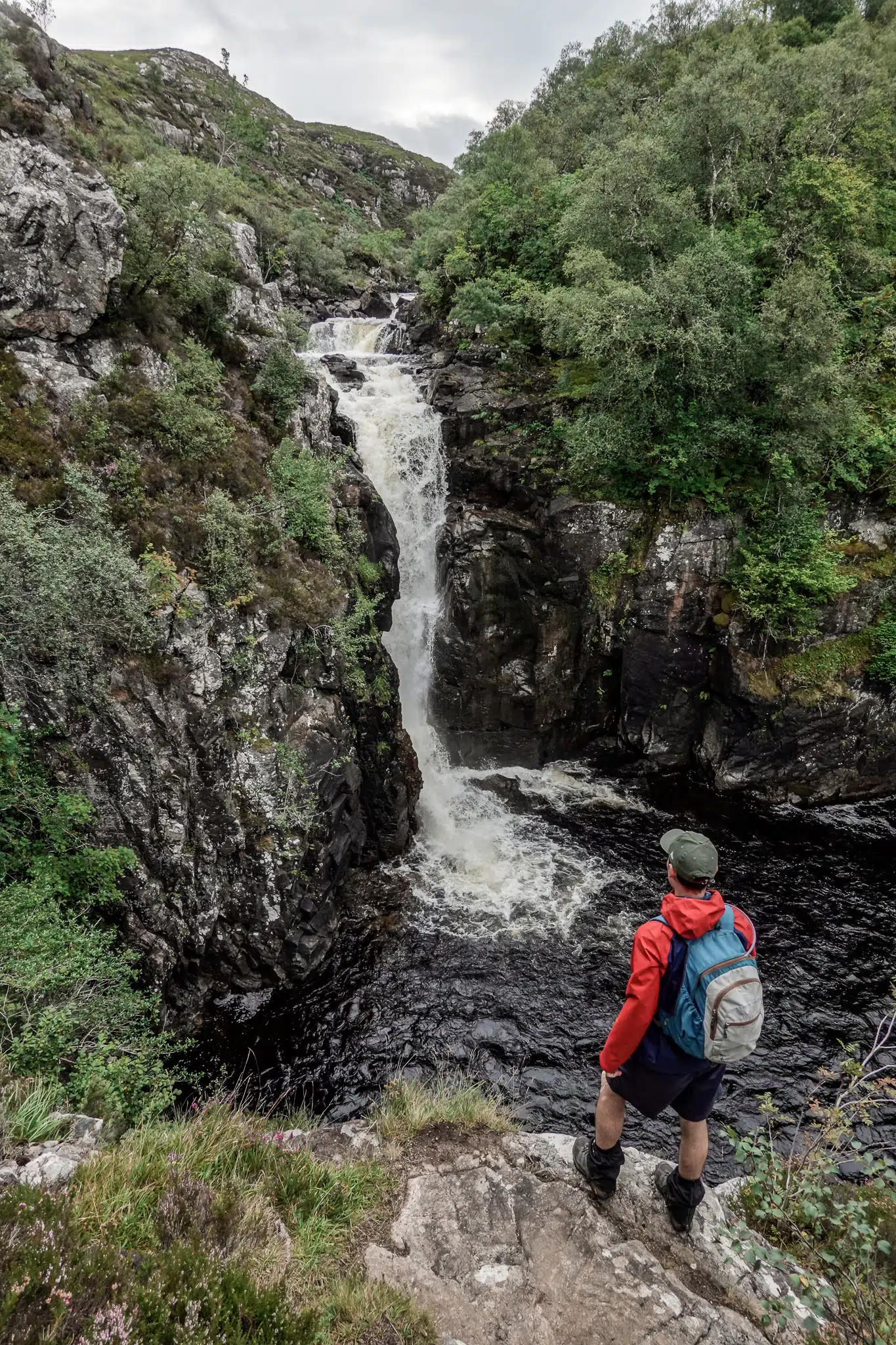
7. Wailing Widow Falls Loop
- Type: Loop
- Distance: 1.7km
- Time: 30–60 minutes
- Accumulated elevation gain: 55m
- Difficulty: Moderate
- Trailhead: Wailing Widow Falls Car Park
North of Ullapool, you’ll find more spectacular waterfalls, including the epic 30-metre Wailing Widow Falls. To reach the base of the falls, from the small roadside car park, you’ll follow a short rough track following the stream formed by Loch na Gainmhich.
Now, most people complete a short out and back, which is by far the easiest and safest option. However, it is possible to scramble to the top of the falls via a steep and rough ascent to the left of the waterfall. We only recommend this scramble to experienced hikers.
At the top of the falls, you’ll have even more breathtaking views. To complete the loop and with Loch na Gainmhich to your left, make your way through the boggy terrain towards the road. You’ll then turn right, descending the road back to the car park.
Keep in mind that you’ll pass the top of Wailing Widow Falls as part of the hike to Eas a’ Chual Aluinn – Britain’s highest waterfall! Due to adverse weather conditions, we decided we couldn’t hike to Eas a’ Chual Aluinn the day we visited Wailing Widow Falls. If you also experience poor weather, consider the short Wailing Widow Falls hike and then, hiking to Eas a’ Chual Aluinn, perhaps on another day once the weather has improved.
Read more: How To Visit Wailing Widow Falls (Loch Na Gainmhich Waterfall)


8. Bone Caves Circuit
- Type: Loop
- Distance: 5km
- Time: 1.5 hours
- Accumulated elevation gain: 230m
- Difficulty: Easy
- Trailhead: Allt nan Uamh Car Park
Close to Ardvreck Castle is a fantastic short trail, takes in four epic caves. After passing the quaint river stream of Allt nan Uamh, the valley surrounding you begins to narrow. Eventually, you’ll arrive at a junction – follow the right-hand fork to head to the caves.
The trail gently ascends as you reach the Crag of the Caves. Soon enough, you’ll be exploring the Bone Caves, including Badger, Reindeer and Bone Cave, plus Fox’s Den. All of the caves are equally spectacular and worth exploring inside.
Afterwards, there’s an option to add an out and back to Rana Hole; but, given it’s gated off, we don’t recommend visiting as it’s quite underwhelming. Either way, you’ll eventually descend the Crag of Caves, heading to the valley floor. The trail sharply loops around an initially boggy track facing opposite the caves and rejoins the track leading to the car park.
Read more: Ultimate Guide To The Bone Caves, Inchnadamph On The NC500


9. Suilven
- Type: Out & Back
- Distance: 21km
- Time: 6.5 hours
- Accumulated elevation gain: 896m
- Difficulty: Moderate
- Trailhead: Canisp Road (head towards Glencanisp Lodge)
Suilven (731m) may only be classified as a Graham (610–762m), but it is one of the most recognisable mountains in Scotland. Excluding the incredible mountain ranges in Torridon, the hike to Suilven may be one of the best on the NC500 route.
In good weather conditions, Suilven’s incredible outline can be seen straight from the get-go. For us, with thick mist and low clouds, we weren’t able to see Suilven from afar until we made the return journey.
The trail to the foot of Suilven is quite a flat one. But then, you have a steep ascent of around 500m to reach the peak.
Even though it was a whiteout at the top, luckily for us, the mist and clouds began to clear. Glimpses of the glorious array of lochs spread over the landscape began to appear.
Shortly, as we began our descent, the mist and clouds completely disappeared and we had those unbeatable views from Suilven, that we had heard so much about.
Other than the Fisherfield Six (42km), Suilven is the longest NC500 hike detailed in this guide, totalling a half-marathon (21km)! So, you’ll need to dedicate almost a full day to climb it. Thankfully though, Suilven is nowhere near as challenging as the 20km An Telleach or any of the Torridon ‘Big Three’, which involve difficult high-grade scrambling and even more vertical gain. Indeed, Suilven is long, with one steep push at the end, but it’s certainly doable for most capable hikers.
Being one of the most beloved mountains in Scotland, Suilven should be high on your NC500 hiking to-do list.
Read more: Suilven – How To Hike This Iconic Scottish Mountain


10. Falls of Kirkaig
- Type: Out & Back
- Distance: 7km
- Time: 1.75 hours
- Accumulated elevation gain: 215m
- Difficulty: Easy
- Trailhead: Inverkirkaig Car Park
Another incredible waterfall walk to check out along the NC500 is the powerful Falls of Kirkaig. Following River Kirkaig to your right, the well-defined undulating trail initially steers you through the forest, slightly away from the river. Soon enough, you’ll veer closer to the river, revealing several sets of nice cascades.
The trail then ascends into the heather moorland and begins to reveal the stunning nearby mountains such as Suilven. Eventually, you’ll reach a grassy knoll and a path heading towards the river and then steeply descending to the base of the falls. As you scramble down, you’ll have several viewpoints of the waterfall at different heights. Of course, we recommend getting right down to the bottom to truly experience the waterfall in all its glory!
All in all, the Falls of Kirkaig is an amazing waterfall, which is simple and easy to reach. We highly recommend adding the Falls of Kirkaig to your NC500 hiking itinerary!
Read more: Falls of Kirkaig – The Complete Hiking Guide


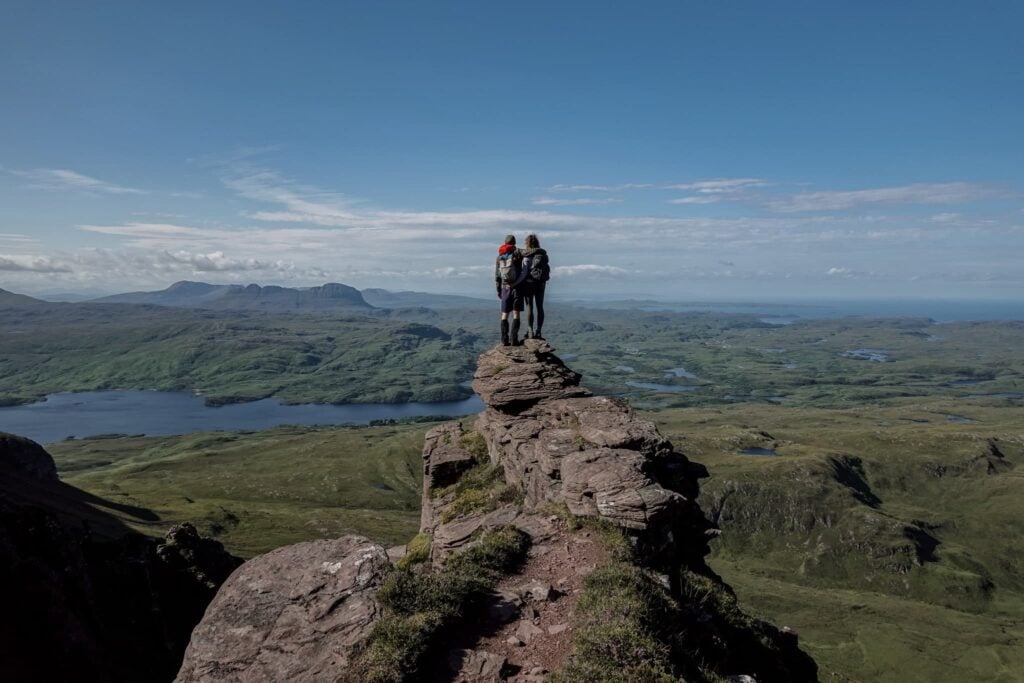
11. Stac Pollaidh
- Type: Loop
- Distance: 4.3km
- Time: 1.75 hours
- Accumulated elevation gain: 475m
- Difficulty: Easy
- Trailhead: Stac Pollaidh Car Park
Stac Pollaidh is one of the best shorter trails you can hike along the NC500. Better yet, hiking Stac Pollaidh for sunrise is an absolute treat in good conditions, as golden hour will put on a spectacular show!
The short but steep trail will have you working hard right from the trailhead. In the early morning, expect to be joined by some shy grazing deer.
From atop the eastern ridge of Stac Pollaidh, you’ll have spectacular views of the loch filled lands, similar to the views atop Suilven. From there, you’ll find a path, circling around the summit peaks, steering you to the western ridge. There is an option to scramble to the top of the western ridge; but, with strong wind gusts and inevitable rain, we didn’t bother! Besides, the eastern ridge already provides extraordinary views that are much easier to ascertain.
The trail then descends from the foot of the western ridge through boggy terrain, forming a loop as it veers left to the car park.
Hiking Stac Pollaidh is a phenomenal way to start the day, before cracking on with another NC500 hike!
Read more: Stac Pollaidh – The Best Short Hike In Assynt, Scotland


12. Quinag
- Type: Loop with 2 x Out & Backs
- Distance: 15.5km
- Time: 6 hours
- Accumulated elevation gain: 1,200m
- Difficulty: Moderate
- Trailhead: Quinag Car Park
Alongside Suilven and the mighty mountains of Torridon, Quinag is easily one of the best hikes on the NC500 route. Quinag is a phenomenal mountain complex with three Corbetts to climb and conquer. Initially, you’ll follow a flat path towards Quinag. You’ll turn left onto a pathless section covered by a natural rocky rib to help you avoid the boggy terrain.
Soon enough, you’ll reach a defined path, steeply steering you to the first Corbett – Spidean Coinich (764m). After descending this first Corbett on some epic ridge trails, you’ll again have a steep climb to reach the second Corbett.
On the way, you’ll reach a peak at the junction of Quinag’s ridges, where you’ll have more breathtaking views.
From there, the ascent is more gradual as you arrive at the second Corbett – Sail Gorm (745m). This Corbett is characterised by a spacious plateau, offering glorious views of the north coast and the quartzite peaks of the North West Highlands.
Being the first out and back, you’ll retrace your steps, before heading to the third Corbett (Sail Gharbh – 808m), which requires a second out and back endeavour. The trail to the highest of the three Corbett summits is actually the least steep. From the cairn, you’ll gain exceptional views of the surrounding lochs and mountain ranges.
Again, you’ll retrace your steps, and then descend into the valley to complete the hike. Quinag is truly a must for your NC500 hiking itinerary – we thoroughly enjoyed it!
Read more: Quinag Hike – The Complete Guide To Bagging 3 Corbetts

13. Eas a’ Chual Aluinn
- Type: Out & Back
- Distance: 9.75km
- Time: 3 hours
- Accumulated elevation gain: 480m
- Difficulty: Easy
- Trailhead: Layby on A894 (200–300 metres south of Loch na Gainmhich Waterfall Car Park)
One of the best hikes in the North West Highlands is the trek to Eas a’ Chual Aluinn – Britain’s Highest Waterfall (200 metres). Considering this waterfall is Britain’s highest, the hiking trail is underrated and not as well known as we had expected it to be. Undoubtedly, when it comes to NC500 waterfalls, Eas a’ Chual Aluinn is one of the best to chase.
Admittedly, this trail only gets you to the top of the falls, where your views of the waterfall are quite limited. Bless our drone for capturing this incredible waterfall! Honestly though, even just seeing the top of this magnificent waterfall is worth all of the effort.
This trail initially guides you past the top of Wailing Widow Falls. With Loch na Gainmich to your right, you’ll climb a gradually steepening path alongside a rocky ravine that soon guides you to Loch Bealach a’ Bhuirich.
After passing this loch, you’ll once again ascend, this time on an increasingly rocky track. The trail then begins to wind and descend through boggy terrain towards the waterfall. You’ll know you’re close when you start to see a widening stream of cascades.
Top of the Falls
To see the top of the falls, you have two options. You can either descend to the lip of the falls, which gets you quite close to the top of the waterfall, positioned to your right. Otherwise, you can follow a path to the right of the falls, following the cliff’s edge, that eventually leads you to a flattened area. Here, you’ll be further away from the waterfall, which will be seen to your left; but, you’ll be able to see a bit more of the falls.
As mentioned before, either way, you’ll only get to see the top of the falls. But, after some decent rainfall, the power of the waterfall cascading from the cliffs is still an incredible sight to see!


DJI Air 2S


Capture breathtaking aerial photography and videography with the DJI Air 2S. The DJI Air 2S Fly More Combo comes with all of the necessary accessories such as the remote controller, spare batteries and battery charger.
14. Castle Varrich
- Type: Out & Back
- Distance: 3.12km
- Time: 0.75 hours
- Accumulated elevation gain: 115m
- Difficulty: Very Easy
- Trailhead: Castle Varrich Parking
It would be rude to not cover some castle trails whilst exploring the NC500. Castle Varrich lends itself to a short and easy route in Tongue on the north coast of Scotland. After completing the best of the NC500 hikes along the west coast of the route, and maybe even after climbing Scotland’s northernmost Munro – Ben Hope, or neighbouring Ben Loyal, the Castle Varrich walk might be your next trail on the itinerary.
Compared to some of the more challenging trails along the NC500, the Castle Varrich walk is really a gentle stroll through serene forest and heathland. Atop Castle Varrich are splendid views of the Kyle of Tongue. Not to poo-poo Castle Varrich itself; but, it didn’t quite stack up to the other incredible castles along the NC500. Still, it’s a nice enough walk and worth checking out for a quick adventure.
Read more: Castle Varrich Walk On The Kyle Of Tongue, Scotland


15. Duncansby Head
- Type: Out & Back
- Distance: 3km
- Time: 0.75 hours
- Accumulated elevation gain: 80m
- Difficulty: Very Easy
- Trailhead: Duncanbsy Head Car Park
Around the corner from the famous John o’ Groats, is the spectacular Duncansby Head. In fact, starting from the Duncansby Head Lighthouse, you’ll have only a short distance to reach the fenced viewpoint of the incredible Stacks of Duncansby. This natural attraction is one of the most visited along the NC500 and deservedly so.
By following the coastal track, it’s another 800 metres to arrive at the next best viewpoint of the Stacks of Duncansby. Along the way, there are epic cliff gaps to enjoy. Once you arrive at the viewpoint, you’ll feel close to the action, with the mega sea stacks perched right in front of you!
With the east side of the NC500 route lacking mountain ranges, you’ll have to find solace in flatter coastal walks during this part of your itinerary. Despite only being a short walk, Duncansby Head is certainly a highlight of any NC500 itinerary!
Read more: Duncansby Head – How To See The Lighthouse And Sea Stacks


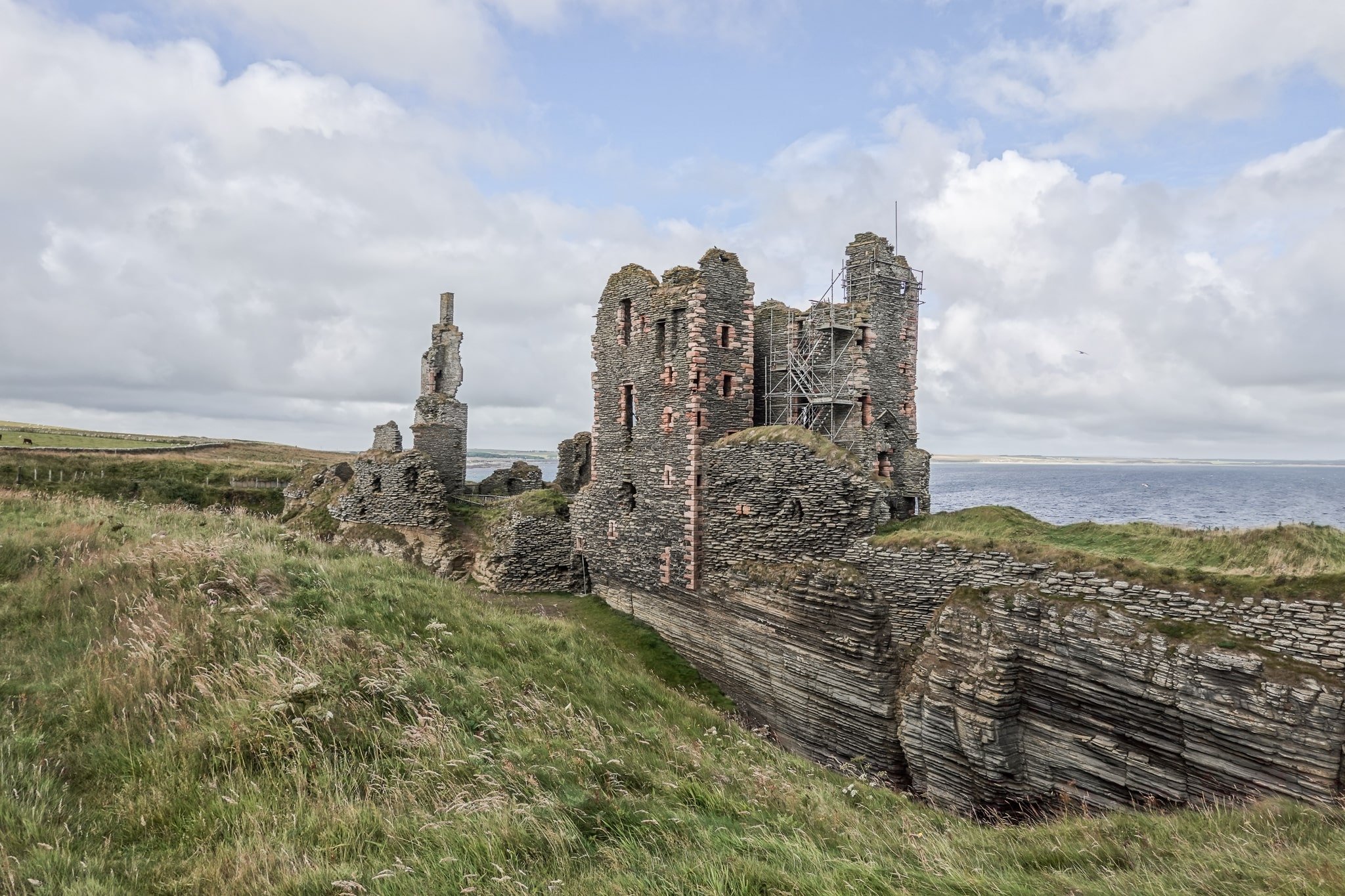
16. Castle Sinclair Girnigoe
- Type: Out & Back
- Distance: 2km
- Time: 0.75 hours
- Accumulated elevation gain: 25m
- Difficulty: Very Easy
- Trailhead: Noss Head Car Park
Alongside Old Keiss Castle, Castle Sinclair Girnigoe is another fascinating castle to explore in the Caithness area of the NC500. Located close to Wick, and next to Noss Head, the castle is well-placed for a short coastal walk. Again, the naysayers might claim this is not much of a hike; but, at 2km, we’re happy to include this glorious castle trail on the list. There are even cool sea stacks and an isolated bay to explore, making this much more than just an out and back to a castle.
Read more: Castle Sinclair Girnigoe – An Excellent Walk At Noss Head, Scotland

17. Old Keiss Castle
- Type: Out & Back
- Distance: 1.9km
- Time: 0.5 hours
- Accumulated elevation gain: 10m
- Difficulty: Very Easy
- Trailhead: Keiss Harbour
Echoing the sentiments of Castle Sinclair Girnigoe, the coastal walk to Old Keiss Castle is not a challenging or long trail. At around 1.9km, this coastal walk is certainly short and sweet. With barely any elevation gain, you’ll likely finish this adventure in less than half an hour. You can expect a quiet walk with lovely ocean views, soaring seabirds and interesting castle ruins.
Read more: Keiss Castle Walk On The NC500 – The Complete Guide


18. Fyrish Monument
- Type: Out & Back
- Distance: 6.3km
- Time: 1.5 hours
- Accumulated elevation gain: 280m
- Difficulty: Easy
- Trailhead: Fyrish Car Park
If you’re exploring the NC500 in a clockwise direction, it’s very likely that your final hike will be to the Fyrish Monument. You’ll follow the short but steep Jubilee Path, meandering through lovely forest, to reach the impressive monument. Not only will you have this landmark to check out; but, from the peak, you’ll have decent views of the Cromarty Firth with the bulky mountains of Ben Wyvis in the distance.
As you’ve discovered, the eastern side of the NC500 route is much flatter. As a result, there aren’t as many hiking trails to explore on this part of the route. However, we recommend squeezing in this final hike to Fyrish Monument before finishing your trip back in Inverness.
Read more: Fyrish Monument Walk In Alness – The Complete Guide


Other Essential NC500 Hikes
Below, are some of the other best mountain walks along the NC500.
Unfortunately, due to adverse weather, we had to cancel plans to hike some of the best mountain trails along the NC500. This meant missing out on An Teallach, which possibly has one of the finest mountain ridges on mainland Britain.
In terms of the Toriddon ‘Big Three’, we were fortunate enough to hike Beinn Alligin, but we missed out on Beinn Eighe (Western Summits) and Liathach. We simply didn’t have time to complete the Fisherfield Six or Ben Loyal (on a 10 day trip), but poor weather also foiled our plans to hike Scotland’s northernmost Munro – Ben Hope.
If you can, try and include these walks on your NC500 trip, as these trails are some of the finest on the NC500, and indeed, in Scotland. Yet, bear in mind, that some of these trails require hardcore Grade 3 scrambling, so are suited for seasoned hikers with scrambling experience.
- An Teallach: Loop | 20km | 9–10 hours | Accumulated elevation gain: 1,415m | Difficulty: Very hard | Trailhead: An Teallach Car Park
- Beinn Eighe (Western Summits): Loop | 18km | 7–9 hours | Accumulated elevation gain: 1,116m | Difficulty: Hard | Trailhead: Beinn Eighe Car Park
- Liathach: Loop | 11.5km | 11.5km | 8–10 hours | Accumulated elevation gain: 1,326m | Difficulty: Very hard | Trailhead: Liathach Parking
- Fisherfield Six: Loop | 42km | 12–18 hours | Accumulated elevation gain: 2,254m | Difficulty: Very hard | Trailhead: Corrie Hallie Car Park
- Ben Hope: Out & Back | 7.5km | 4–6 hours | Accumulated elevation gain: 964m | Difficulty: Moderate | Trailhead: “Parking for Ben Hope trail” (Google Maps)
- Ben Loyal: Out & Back | 13.75km | 5.5–6.5 hours | Accumulated elevation gain: 804m | Difficulty: Moderate | Trailhead: 58.457500, -4.428100
NC500 Hikes Map
For your convenience, here’s an interactive map, showing the location of all of the best NC500 walks.


Other Worthwhile Short NC500 Walks
Of course, there are many other short walks to amazing beaches, castles and other natural/historical attractions along the NC500. Basically, we had to draw the line somewhere! So, if the walk was less than 1.5km, we haven’t included a description in this guide.
But, please find below a photo list of worthwhile NC500 attractions to visit, which generally involve a bit of walking. We have roughly presented in order of an NC500 trip explored in a clockwise direction. Feel free to add these shorter walks to your NC500 itinerary. For sure, some of these attractions make for some of the NC500 route’s best stops.


For your convenience, you’ll also find these locations on the interactive map below.


NC500 Hikes Recap
Is the NC500 worth it? Absolutely, yes. The NC500 is not only an epic road trip but a route full of phenomenal walks. By following this comprehensive NC500 hiking guide, you’ll be able to plan your own magnificent NC500 hiking itinerary with ease. Whether it’s a monster mountain trail in Torridon or a casual walk to a castle, you’ll find all of the essential details in this NC500 guide. Certainly, feel free to use this guide as a NC500 route planner.
To further assist in your trip planning, continue reading below to learn about accommodation (camping and non-camping recommendations), hiking essentials and bonus tips for the NC500!
Check out our Best Loch Lomond Walks and Best West Highland Walks guides
Our Experience Doing NC500 Hikes
Personally, adverse weather conditions meant our hiking itinerary didn’t quite go to plan (we visited in August). Unfortunately, this meant we had to cancel hiking some of the mountain trails. Inevitably, our itinerary was chaotically thrown together in response to the weather. For this reason, it’s best to roughly know what hikes you’d like to do, make a loose plan around this and prepare to be flexible with your itinerary.


Planning Your NC500 Hiking Itinerary
Trip Length: we recommend anywhere between 7–18 days for your NC500 hiking adventure. A 10 day trip will give you enough time to hike most of the trails; but, you’d have to skip some of the longer day hikes. A trip closer to the 2–3 week mark would give you enough time to conquer all of the trails in this guide; plus, enough time to check out all of the other attractions along the NC500.
A trip between 4–6 days is certainly doable and you’d get to enjoy some awesome hiking. But, you’d miss out on many mind-blowing walks and you’d be a bit rushed to complete the overall NC500 route.
Best Location For Hikes On the NC500
Let’s talk about the best location for hikes along the NC500. For a hiking-focused NC500 trip, you’ll need to base yourself mostly on the west side of the NC500 route as that’s where the epic mountain ranges are located.
All of the best mountain walks along the NC500 are located in and around Torridon, Ullapool and Lochinver in the Wester Ross and Sutherland areas. To cover the best NC500 hikes, at least 3/4 of your trip will be based on the west side. With this said, you’ll just need to give yourself enough time to get around the entire route!
Best Time to Do Hikes On the NC500
Many of the epic mountain ranges along the NC500 route will be covered in snow anywhere between October and April. Hiking the mountain trails along the NC500 in snowy conditions is only permitted for experienced hikers with specialist snow-trekking equipment.
To avoid snowy and potentially unsafe trails, visit between May and September for a higher chance of clear trails. The locals will tell you that the best weather in Scotland is between May and July – visit at this time to have less disruption to your hiking plans.
Getting to Scotland
To do this trip from abroad, it makes sense to fly to Inverness – where the NC500 starts and finishes.
Booking Flights


Skyscanner is our go-to website for booking flights. If you’re looking to find the cheapest flights, we recommend getting the ball rolling with a Skyscanner search. It allows you to scan all airlines and platforms to find the cheapest airfares.
To find out more about booking the cheapest flights, read our Skyscanner review.
Getting Around the NC500
Traditionally, the NC500 is a road trip so you’ll need your own set of wheels. Plus, many sections of the NC500 either have no or very limited public transport. If you don’t have a car, we highly recommend hiring one for your NC500 road trip.
Car Hire


If you don’t have your own car, you should hire one using Discover Cars. Personally, we use Discover Cars and highly recommend them for finding your ideal car hire at an affordable price. Booking online is super easy and the free cancellation policy is great.
To find out more about renting a car with Discover Cars, read our Discover Cars review and Discover Cars Insurance review.
NC500 Accommodation Recommendations
It’s well known that accommodation along the NC500 is limited. So, it’s highly recommended to book far in advance (3–6 months at least), particularly for a summer trip.
Admittedly, we booked our NC500 hiking trip (in July for an August trip) fairly last minute, so we had very few options in terms of camping. Many campsites were completely booked out on the west side of the NC500 route, where all of the best hiking is! So, we just had to book what was available.
This meant booking some non-camping accommodations somewhat inconveniently located for the hikes we wanted to do and having an extended stay at one campsite in Ullapool. So, we can’t recommend you follow our itinerary exactly when it comes to accommodation. But, we can recommend the ideal accommodation options for your NC500 hiking trip.
Of course, wild camping is always an option in Scotland. Honestly speaking though, with all of the hiking that we do, we prefer a campsite with a shower and basic amenities.
Best Accommodation For Doing NC500 Hikes
Given the best walks are located along the west coast of the NC500 route in Wester Ross, you’ll want to find accommodation around there.
Conveniently located in Torridon, our first camping recommendation is Torridon Camp Site. The Torridon Camp Site only accommodates tents and has basic amenities including free showers. Alternatively, the nearby Torridon Youth Hostel is a non-camping option brilliantly located for your Torridon hiking adventures.
Stay at Torridon Youth Hostel


- Idyllic location near Loch Torridon with mountain views
- Spacious self-catering kitchen
- Large dining area
Ardmair Point Holiday Park
Our second camping recommendation is Ardmair Point Holiday Park in Ullapool. This campsite was our absolute saviour! With all other campsites on the west side of the NC500 booked out, Ardmair Point Holiday Park was literally our only option for camping that could be booked in advance. Only a non-electric tent pitch was available and so we booked that at a very reasonable £20/night. A gazebo added £3/night.
The campsite had great facilities, wasn’t overcrowded and provided a great base to enjoy sunsets and sunrises from Ardmair Point.


Usually, for the NC500, it’s recommended to book different accommodation every night for a 7–10 day trip to cover the entire route. However, particularly for campers, this can be really time-consuming to set up at a new campsite every evening. Because all of the campsites had been booked out we didn’t really have a choice but to book the one campsite for four nights.
Even though Ardmair Point Holiday Park wasn’t that close to many of the best NC500 hikes around Lochinver and Inchnadamph, we enjoyed the convenience of being based at just one campsite. Although, be prepared for extra fuel costs. Most days, we had to drive 35–60 minutes one-way to reach many of the trailheads and attractions north of Ullapool, that fall in the North West Highlands.
Other Accommodation Recommendations
Given the best walks on the NC500 are located on the west side of the route, you may not spend many nights along the northern or eastern sections of the route. But, you’ll probably need at least one or two nights along these sections as you complete your NC500 adventure.
Not far from the most northern point of mainland Britain, Thurso has plenty of accommodation options, even when booking last-minute. Also, compared to other non-camping accommodation options along the NC500, you’ll find staying in Thurso is great value for money.
You’ll also likely need a night in Inverness when starting or finishing the NC500 route.
In terms of starting the NC500 route, we actually spent a night in Perth. Travelling from Manchester, and departing after work on a Friday night, it was a good halfway point for a rest. We recommend staying at Sky Lodge Perth, where you’ll enjoy a comfortable stay before cracking on with your NC500 hiking trip.
Of course, when searching for camping along the NC500, we recommend using WikiCamps to find a campsite most conveniently located for your hiking itinerary. For non-camping options, we recommend using Booking.com or Airbnb.
Hiking Gear Essentials For the NC500
These are our gear essentials for doing walks on the NC500.
Osprey Skarab 30


The Osprey Skarab 30 is our go-to hiking backpack for day hikes. This well-designed unisex backpack is comfortable and spacious, so you’ll have plenty of space to pack everything without feeling the strain on your upper back.
Osprey Ultralight Raincover


A waterproof backpack cover is an absolute must when you’re adventuring outdoors. The Osprey Ultralight Raincover Medium is a high-quality waterproof cover that’ll keep your backpack bone dry.
GRAYL Reusable Water Bottle


The GRAYL GeoPress is the best water filter bottle that allows you to purify 710mL (12 ounces) of water. This bottle will make water safe to drink wherever you’re hiking.
BUFF Original Ecostretch


The BUFF Original Ecostretch is a great option when it comes to multifunctional headwear. We use the Ecostretch as a neck gaiter to keep the sun off our necks and it helps us keep warm in cooler climates.
Sony Cybershot RX100 VII


Capture epic photos and videos with the Sony Cybershot RX100 VII. This is hands-down the best compact camera. We love using this simple point-and-shoot camera when we’re hiking as it’s lightweight and durable.
To find out more about all of the gear that we use and recommend, read our guides about our favourite hiking gear, travel gear and camera gear. Otherwise, read our comprehensive travel packing checklist.
Camping Gear Essentials For the NC500
Camping in Scotland is a fantastic experience; but, you’ll need to have the right gear when visiting in summer to avoid being bitten by midges. Thankfully, there are a few helpful preventative measures you can implement to stop them from biting you.
This involves having the right camping equipment, including a camping living area, which is one of our best EVER purchases. It works similarly to a gazebo with walls; but, without the heavy poles/equipment and time-consuming setup. In fact, it’s most similar to a tent, considering its general design and how quickly it is to set up.
You may also want a Smidge Head Net and Mosquito Repellent Bracelets.
Otherwise, these are some of our camping gear essentials for the NC500.
Camping Gear


Trail Navigation For NC500 Hikes
Excluding some of the shorter castle or beach walks, there are very challenging mountain trails on the west side of the NC500 route to navigate. So, we recommend using maps or GPS-guided directions to help you navigate harder walks on the NC500.
Bonus Tips For Doing NC500 Hikes
- Book early: make sure to book your NC500 hiking trip well in advance. Campsites along the route can book out around 6 months ahead of time.
- Route direction: we recommend going in a clockwise direction. That way, you’ll reach the Wester Ross area much quicker, compared to driving anti-clockwise from Inverness. This will allow you to crack on with hiking the best trails straight off the bat!
- Use WalkHighlands.com: there is no way that any company or blogger can compete with the wealth of information and detail that exists on the WalkHighlands website. We used this website quite a lot to plan the walks that we did along the NC500.
- Other great places to visit on the NC500: of course, we haven’t covered every attraction and activity along the route. Visiting Cape Wrath is just one place, not detailed in this guide, that’s worth visiting during a trip to the area.
- NC500 walking challenge: why not complete the virtual challenge of walking the NC500? By paying for and downloading the mobile map, you can virtually complete the NC500 route. So, how long does it take to walk the NC500 virtually? Well, by doing it virtually, you can take as long as you want – days, weeks or months!
Share this post about walks on the NC500 with your hiking partner on Facebook.
Leave a comment