
To hike Quinag is to truly experience the rugged wilderness of Assynt, Scotland. The mightily impressive, not to mention, enjoyable trail around the Quinag massif heads high above the splendid Loch Assynt and conquers three immense Corbett peaks. The most breathtaking views of the surrounding mountains, lochans and isles out to sea make Quinag a truly memorable hike along the NC500.
Read 18 Epic NC500 Hikes: The Best Walks On The NC500
Table of Contents
About the Quinag Walk in Assynt
Quinag is a mountain range made up of three Corbetts. The individual peaks are known as Spidean Coinich (Mossy Peak) which stands at 764 metres above sea level (masl), Sail Gharbh (Rough Heel) which stands at 808masl and Sail Ghorm (Blue Heel) which stands at 776masl.
The Quinag trail is a, roughly, circular hiking route. Basically, it includes two out and back summit walks along the loop trail in order to cover all of the peaks. At almost 16km long and with 1,200m elevation gain, it’s a big day hike that requires a fair amount of effort. That being said, the trail is very user-friendly and easy to follow. Certainly, in good weather, it’s a great hike for most abilities.
Some of the best views of the other Assynt mountains are seen from the summit of the Corbetts on Quinag. Loch Assynt looks particularly epic in the valley below. It’s little wonder such good memories behold those who choose to climb this fantastic massif.

Where is the Quinag Trail?
The trail to Quinag is located in the Sutherland region of northwest Scotland. This part of the Highlands is some of the most remote and sparsely populated. Yet, with that comes a beauty unrivalled, with hidden beaches and lochs, ancient woodland and incredible mountains to explore.
Quinag is owned by the John Muir Trust, the same as Suilven, with both trusts sharing ownership of nearby Loch Assynt.
How to Pronounce Quinag
On appearance, Quinag looks fairly straightforward. But, remember, this is Scotland and these place names are generally Gaelic. So, with that being said, Quinag is not pronounced as you read it (minus 10 points to me). In fact, the correct pronunciation is coo-nyag. There you go. And it means ‘milking pail’.
How To Climb Quinag
In this guide, we’ll give a brief trail description complete with a GPS map and hiking stats. We’ll discuss how to get to Quinag, other hikes to do in the area and around Loch Assynt, where to stay and when is the best time to hike.


Quinag Hiking Map and Preview
- Trail Type: Loop with 2 x Out & Backs
- Distance: 15.5km
- Time: 6 hours
- Accumulated elevation gain: 1,200m
- Difficulty: Moderate
- Trailhead: Quinag Car Park
- Map: Wikiloc
Quinag Walk Description
From the Quinag Trailhead Car Park, firstly head back down the road, in the Loch Assynt direction, for a few metres. Then, on the opposite side, you’ll see the start of the Quinag hike, marked by a small stone wall with an information plaque on top.
From here, you’ll see the huge massif of Quinag face on. It looks a little intimidating for sure, but that’s the adventure, hey?
Cross the bridge over the small stream and follow the trail forward across the grassy moorland. At about 500m, the trail forks. There’s a cairn to mark the spot. From here, take the left side trail to continue up to Spidean Coinich. The right-hand trail will be your return route.
Spidean Coinich
The climb up to Spidean Coinich is the hardest of the three summits. A GPS map is useful for this section as the trail can drop in and out. But, essentially, you’ll head straight up, across the rocky landscape, towards the first peaks of Spidean Coinich.


At the 3km mark, and around 620masl, the trail dips, briefly, before resuming the climb to Spidean Coinich. The trail here is clear and the views of the peak are fantastic.
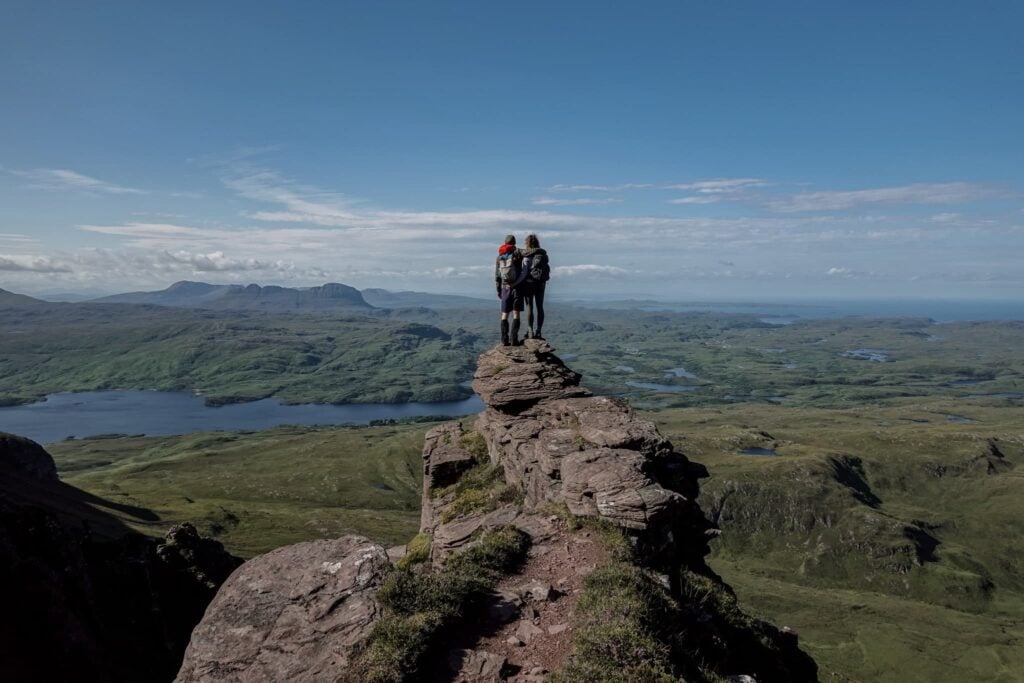
Reaching the peak of Spidean Coinich is an incredible feeling. Standing at 764m above sea level, with the first of the three mountains conquered at Quinag, reveals outstanding views across Assynt. Quinag surely sits in one of the most breathtaking parts of Scotland. Looking back towards the trailhead, the views of Loch Assynt are sublime. Behind, sits the formidable shape of Suilven. It was interesting to have such good views of this stalwart on the Assynt landscape, given we’d had such terrible weather during our actual hike of Suilven, where we’d seen very little of it at all.
Spidean Coinich Ridge Walk
From Spidean Coinich, it’s onwards to conquer Sail Gorm. The trail is clear and cuts through the grassy mountainsides with ease. From Spidean Coinich, the trail, firstly, follows an impressive ridgeline. The mountain humps undulating, sharply, making for an incredibly enjoyable hike. Ahead, and to the right, is Sail Gharbh, the last peak to conquer a little later. Sail Gorm, however, is almost obscured from view at this point. There’s a sharp drop, to the right, that provides excellent views over the small lochan at the bottom – Lochan Bealach Cornaidh.


The trail twists and turns as it navigates the steep descents and ascents, but it’s not too challenging. Again, the views across Loch Assynt and out to Suilven are quite spectacular, as you look to your left.
At around the 5.7km mark, the trail to Sail Gorm is in focus, and what begins is a steady hike to its summit cairn.
As you begin this section of the trail, you’ll pass a small rocky outcrop. Almost a plinth, with the most incredible view. Take care as you access it, but be prepared to have your breath taken away. The view across Assynt from this part of Quinag in Scotland is easily one of the most memorable of the entire hike. The watery landscape of Assynt flows all the way out to sea. Even Loch Assynt appears as a never-ending channel as it cuts through the wilderness.
Further along the trail, you’ll pass an impressive cleft in the rock face of Quinag. Very similar, in fact, to Eag Dubh on Beinn Alligin. Continue past and ascend up to Sail Gorm.


Sail Gorm
You’ll find Sail Gorm, the second of Quinag’s peaks, to be grassier and less rocky than Spidean Coinich. It feels quite flat at the top, certainly with an almost plateau feel about it. We also found it to be incredibly windy! Quite wild really, but then, this is Assynt.


At 776masl, Sail Gorm offers perhaps the best views of the rest of the Quinag massif. In addition, the views facing northwest, and out to sea, are truly wonderful. If it wasn’t so windy, we’d have stayed at the peak of Sail Gorm much longer.
From the peak of Sail Gorm, you can just about spy Kylesku Bridge in the distance down below. To get a good look, you’ll need to walk a little beyond the cairn, and downslope somewhat.


Sail Gharbh
Lastly, the final push to Sail Gharbh and the final peak of the Quinag trail begins. Retrace your steps back down to the ridge. A little after the cleft in the rock, you’ll join back up with the trail you initially descended from Spidean Coinich. At this point, you’ll see a flatter trail, now leading around the mountain to your left. This part of the Quinag trail heads around the ridge and leads across an open saddle, before climbing up to Sail Gharbh.
Heading up to Sail Gharbh is fairly easygoing. Surprisingly, really, given that it’s the highest point of Quinag in Scotland. At the top, a cairn marks the point of 808m above sea level. The views from Sail Gharbh across to neighbouring Spidean Coinich are particularly impressive. The ridge line looks immense, with Loch Assynt and Suilven peeking out from behind.


Return
To return, retrace your steps back to the saddle and then take a sharp path down towards Lochan Bealach Cornaidh at the base. From here, the path continues to the left-hand side of Lochan Bealach Cornaidh, gradually descending the flattish grassy landscape.
Dan and I found this section of the hike the perfect place to smash out some speed hiking. Undoubtedly, the flatter trail made this much easier for us. As did the thought of more sightseeing around the area.
Eventually, you’ll meet back with the cairn signalling the initial fork in the trail, before continuing past and straight back to the trailhead.


Quinag Recap
The Quinag hike is one of absolute tranquillity and remoteness, providing exceptional views across Assynt, Scotland. For a quiet day hike and place to enjoy the Scottish Highlands at its finest, then it would be hard to look beyond the Quinag trail. Its three summits offer differing views of the surrounding Assynt landscape, as well as a good look at its own peaks. Quinag is definitely a hike to remember, and easily one of our favourites on the NC500 in Scotland.


How to Get to Quinag Mountain
Quinag is very easy to get to. If travelling from Ullapool, you’ll take the A835, northwards, past Ardmair and towards Ledmore. At the Ledmore junction, turn left onto the A837. You’ll pass by Loch Assynt on your left, and The Bone Caves on your right. A short drive after passing Ardvreck Castle, look out for a right turn onto the A894. Then, it’s just a case of looking out for the Quinag Trailhead Car Park, located on the right-hand side of the road.
It’s definitely easiest to reach Quinag and complete Scotland’s NC500 for that matter, with your own vehicle.
Of course, if you don’t have access to your own set of wheels, then we recommend hiring something.
Car Hire


If you don’t have your own car, you should hire one using Discover Cars. Personally, we use Discover Cars and highly recommend them for finding your ideal car hire at an affordable price. Booking online is super easy and the free cancellation policy is great.
To find out more about renting a car with Discover Cars, read our Discover Cars review and Discover Cars Insurance review.
Public Transport
From what I can tell, there isn’t any public transport to the Quinag trailhead. At least nothing official anyway. If you’re hellbent on getting to Quinag with public transport in Scotland, then you can certainly take bus 809 from Ullapool to Achmelvich, and alight at Skiag Bridge, just past Ardvreck Castle on Loch Assynt. If you walk for a couple of minutes and turn onto the A894 (the road Quinag is located on), you may be able to pick up bus 804. This bus runs between Lochinver and Kinlochbervie. That being said, whether Quinag Trailhead is an official stop along this stretch of the journey is unknown. Still, I can’t see why a bus wouldn’t stop if you asked. But, since I used my own transportation, I do not know.
If you have or do try public transport, drop your experience in the comments below to help other hikers out.
Weather
Mountain weather can always be unpredictable, especially in Scotland. For your best chances of good weather, you should choose to hike in the summer months. This typically includes hiking between April and September. Hiking Quinag, or anywhere in Scotland, during these months, will give you the best chance of clearer and drier weather.
Of course, hiking outside of these months means an increased chance of poorer weather conditions, and even snow. Hiking in the snow in Scotland should only be done by those with experience in snow hiking. That includes the use of specialist equipment too. To that end, please do not attempt to hike Quinag, or any other Assynt mountain trail, if you don’t have adequate experience.
You can get the most up-to-date mountain weather forecast for Quinag and the Loch Assynt vicinity in Scotland, here.
Accommodation For Quinag, Sutherland
Staying in Assynt is one of the most remote locations to enjoy some Highland tranquillity. Whether you choose to camp, find lodgings, or even wild camp in the wilderness, there’s a little something for everyone. Let’s take a look.
Camping Options
- Ardmair Point Holiday Park: Dan and I camped for a few nights at Ardmair Point Holiday Park. The facilities are great, there’s plenty of space and it’s just a 40-minute drive to get to the Quinag trailhead.
- Achmelvich Beach: you’ll find the majority of other campsite options at Achmelvich Beach. It’s just a quick 15-minute drive from Lochinver and not too far from Loch Assynt. Here, you can happily pitch up practically on the beach. Top options include Shore Caravan Site and North Coast 500 Pods.
Wild Camping
Of course, wild camping is permitted in Scotland. However, campers need to follow a standard set of guidelines. These rules revolve around respecting the countryside and ultimately staying safe. Tents should also be out of view from the roadside, where possible. Also, if using a car park with your camper, don’t linger too long into the day or arrive too early in the evening.
Quinag Cottage
In tiny Achiltibuie is Quinag Cottage, a very popular stay and a great location for hiking Quinag and seeing more of Assynt. The cottage is decorated to a modern standard, and its location is second to none. Located on the Coigach peninsula, the cottage, of course, has exceptional views across the Summer Isles and surrounding mountain landscape. A perfect hideaway.
Hotel Options
- Budget: the Inchnadamph Explorers Lodge is a fantastic hostel option on the shore of Loch Assynt. There’s free private parking and the use of a shared lounge, perfect for relaxing in.
- Mid-range: in nearby Unapool is the Newton Lodge. The views of Quinag and Assynt from this picturesque white house are completely staggering.
- Luxury: over in Ullapool, Ardvreck House scores very highly with guests. The spacious rooms come with a view, the breakfast is delicious and ultimately this hotel makes a great base from which to explore Quinag and the Loch Assynt vicinity.


Other Hikes Nearby
- Stac Pollaidh (Stac Polly): Stac Pollaidh is one of the best shorter trails you can hike along the NC500. Better yet, hiking Stac Pollaidh for sunrise is an absolute treat in good conditions, as golden hour will put on a spectacular show!
- Suilven: Suilven (731m) may only be classified as a Graham (610–762m), but it is one of the most recognisable mountains in Scotland.
- Wailing Widow Falls: just a stone’s throw from Quinag you’ll find the spectacular 15 metre drop waterfall that is Wailing Widow Falls. To reach the base of the falls you’ll follow a short rough track following the stream formed by Loch na Gainmhich.
- Eas a’ Chual Aluinn: this is Britain’s Highest Waterfall (200 metres). But, considering Eas a’ Chual Aluinn is Britain’s highest, the hiking trail is ultimately underrated and not as well known as we had expected it to be. Still, that was great news for us!
- Falls of Kirkaig: another incredible waterfall walk to check out along the NC500 is the powerful Falls of Kirkaig.
- The Bone Caves: close to Ardvreck Castle, The Bone Caves is a fantastic short trail, taking in four epic caves along its quick loop.


Five Hiking Essentials For Quinag, Scotland
These are our five hiking gear essentials for the Quinag trail! You should also pack at least 2–3L of water, snacks, lunch and sunscreen.
Osprey Skarab 30


The Osprey Skarab 30 is our go-to hiking backpack for day hikes. This well-designed unisex backpack is comfortable and spacious, so you’ll have plenty of space to pack everything without feeling the strain on your upper back.
Osprey Ultralight Raincover


A waterproof backpack cover is an absolute must when you’re adventuring outdoors. The Osprey Ultralight Raincover Medium is a high-quality waterproof cover that’ll keep your backpack bone dry.
GRAYL Reusable Water Bottle


The GRAYL GeoPress is the best water filter bottle that allows you to purify 710mL (12 ounces) of water. This bottle will make water safe to drink wherever you’re hiking.
BUFF Original Ecostretch


The BUFF Original Ecostretch is a great option when it comes to multifunctional headwear. We use the Ecostretch as a neck gaiter to keep the sun off our necks and it helps us keep warm in cooler climates.
Sony Cybershot RX100 VII


Capture epic photos and videos with the Sony Cybershot RX100 VII. This is hands-down the best compact camera. We love using this simple point-and-shoot camera when we’re hiking as it’s lightweight and durable.
To find out more about all of the gear that we use and recommend, read our guides about our favourite hiking gear, travel gear and camera gear. Otherwise, read our comprehensive travel packing checklist.
Bonus Tips
- Tourism responsibility: please, as always, remember to leave no trace. Whatever goes up the mountain with you, must come back down with you. With this in mind, let’s keep our trails and countryside as pristine as possible.
- More than Munros: as you can see from the Quinag hike, some of the best mountains in Scotland aren’t Munros, they’re Corbetts and Grahams. Don’t get too bogged down with ‘Munro Bagging’ or you’ll be missing out on an awful lot of stellar hiking.
- John Muir Trust and the Assynt Foundation: the John Muir Trust is responsible for the maintenance of the trail to Quinag. Thanks to them, not only can we tread a better path to the summit, but also fragile habitats can thrive where boot erosion once caused damage. For more information about this project, click here.


Remember to save or pin this hike for when you’re ready to hike the crackin’ Quinag trail in Assynt, Scotland.
Leave a comment