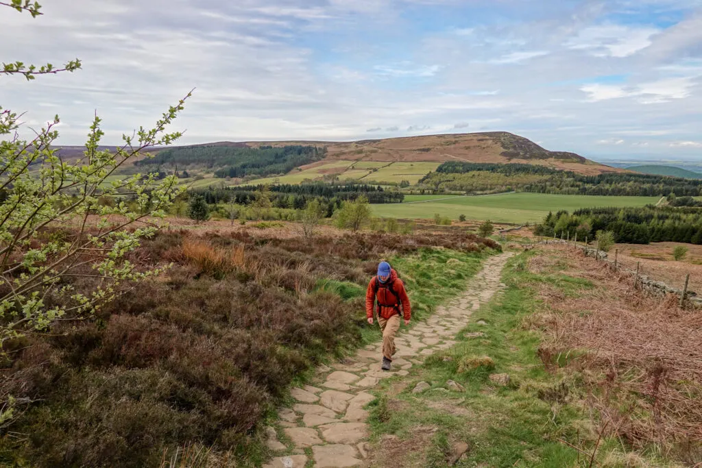
The North York Moors National Park is one of the most underrated destinations to explore (by foot) in the UK. Located in the north of England, the North York Moors offer many outstanding walks to help you explore all of the natural delights of the area. Without a doubt, some of the best walks in North Yorkshire are tucked away in this national park.
In this guide, we’ll show you the 17 best walks in the North York Moors National Park. By the end of this guide, you’ll be clued up about all of the best spots to scope out in the area.
Beck and I have really enjoyed exploring the North York Moors over the years. We’ve completed every single one of these walks (except the multi-day walks, where we’ve only walked some sections), detailed below. We’ve even written individual blog posts about some of the walks. So, please feel free to read these as well, to help you plan your walks in the North York Moors.
Table of Contents
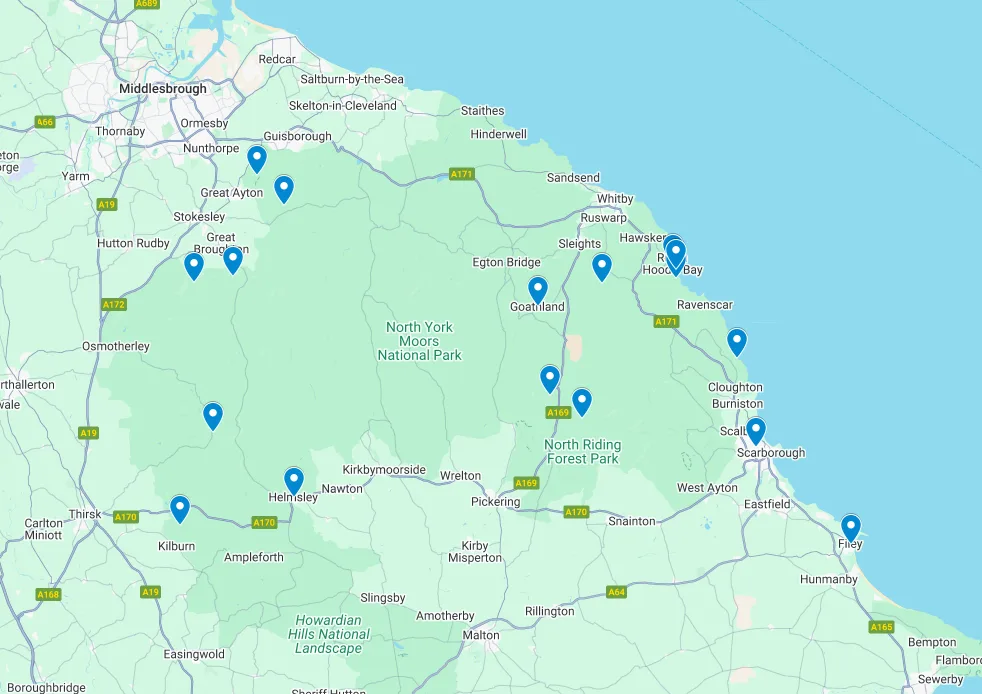
Map of The Best Walks in the North York Moors
For your convenience, we’ve plotted all 17 of these brilliant North York Moors walks onto this interactive Google Maps.

The Best Walks in the North York Moors
First, we’ll run through 14 stellar day walks in the North York Moors. More or less, we’ve listed these walks in order of our personal preferences. So, make sure not to miss any of the walks at the top of the list!
After that, we’ll cover details about three of the most popular multi-day walks that take place in the area.


1. Robin Hood’s Bay to Whitby Walk
- Type: Figure 8
- Distance: 12.5km
- Time: 3–3.5 hours
- Elevation gain: 245m
- Difficulty: Easy
- Trailhead: Robin Hood’s Bay
- Map: Wikiloc
The coastal walk between Robin Hood’s Bay and Whitby is one of the most iconic sections of the multi-day Cleveland Way. If you are to choose one coastal walk in the North York Moors, make it this one!
Whether you walk from Robin Hood’s Bay to Whitby or vice versa, it doesn’t really matter. It’s also possible to do an out and back coastal walk, following the same way back. You can even complete a circular walk between the towns by combining sections of the Cleveland Way coastal walk with the Cinder Track.
As the name of the walk and our guide (link below) suggests, we walked from Robin Hood’s Bay to Whitby. We then got a bus back to Robin Hood’s Bay. We highly recommend this option if you want some more time exploring other walks in the North York Moors!
Read more: Robin Hood’s Bay to Whitby Walk – The Ultimate Guide


2. Roseberry Topping Walk
- Type: Out & Back
- Distance: 2.4km
- Time: 1 hour
- Elevation gain: 120m
- Difficulty: Easy
- Trailhead: Roseberry Topping Public Car Park
- Map: AllTrails
Also known as the Yorkshire Matterhorn, Roseberry Topping is one of the most prominent landforms in the North York Moors. Walking to the peak of Roseberry Topping is undoubtedly the best way to explore this popular natural attraction. The views of the North York Moors from the top of the landmark are superb.
Given the popularity of Roseberry Topping, there are about 101 different trail options to choose from to visit the hill and the surrounding area. Most people do the classic short out and back walk, which is generally only around 2–3km.
Personally, Beck and I did a circular walk, around 8km, which visited both Roseberry Topping and Captain Cook’s Monument. Of course, being an Australian, I had no option but to choose this walking option, which included a visit to this monument!
Read more: Roseberry Topping Walk – The Ultimate Guide to the Best Routes


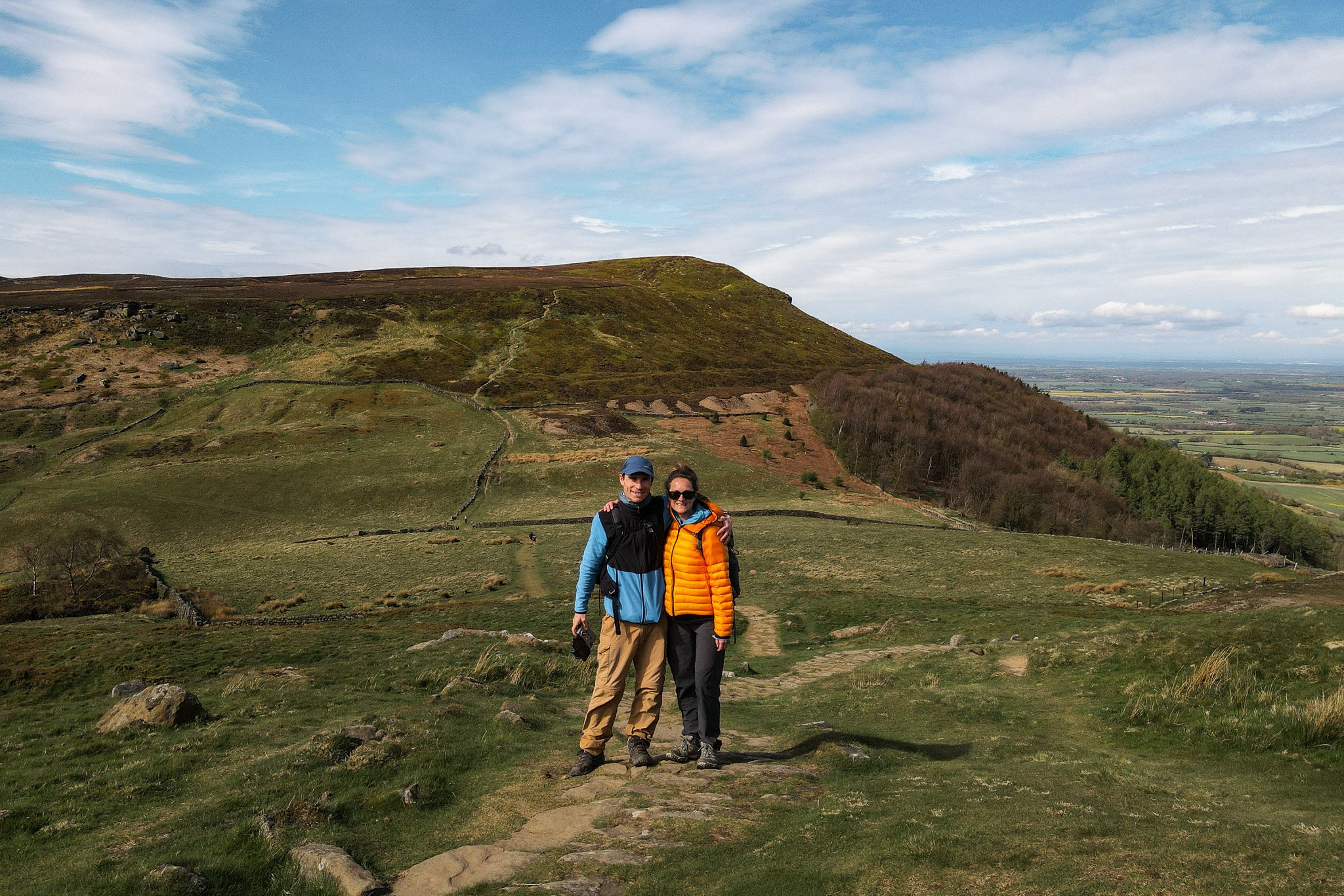
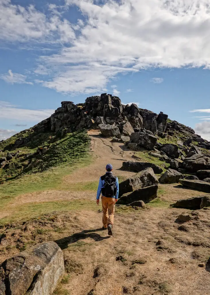
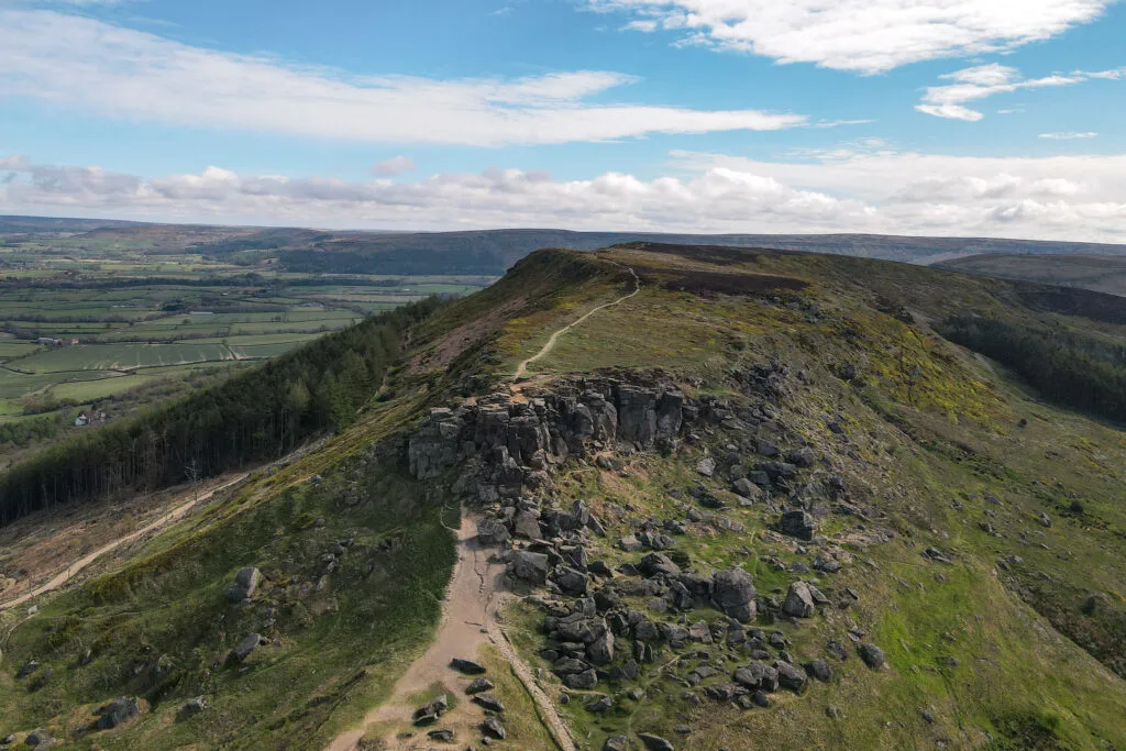
3. The Wainstones Walk
- Type: Loop
- Distance: 14.5km
- Time: 5 hours
- Elevation gain: 615m
- Difficulty: Hard
- Trailhead: Chop Gate Village Hall or Clay Bank Car Park
- Map: AllTrails
The Wainstones are a collection of extraordinarily shaped sandstone crags. Despite its epicness, this landform is barely known. By completing the underrated Wainstones Walk, you can visit this fantastic attraction.
Beyond the Wainstones, the loop walk in and of itself is one of the best moorland circular trails in North Yorkshire. Typically, the walk starts from Chop Gate Village Hall. But you can also do the walk from the Clay Bank Car Park.
Beck and I actually combined the Wainstones Walk and the Lord Stones Walk, which we’ll cover in more detail below.
Read more: Combining The Wainstones Walk and The Lord Stones Walk

4. The Lord Stones Walk
- Type: Loop
- Distance: 4.5km
- Time: 1.5 hours
- Elevation gain: 185m
- Difficulty: Easy
- Trailhead: Lord Stones Country Park
- Map: AllTrails
Not too far from the Wainstones, you’ll find the Lord Stones. In contrast, the Lord Stones are a set of human-made kerbstones, dating back to the Bronze Age. This is when a stone circle was created to mark the perimeter of a burial mound. The stones that remain are what is left of the prehistoric stone circle.
From the Lord Stones Country Park, you can do a short walk to the Lord Stones. The circular walk then ascends Cringle Moor, where you’ll enjoy spectacular views of both the Wainstones and Roseberry Topping.
As mentioned, Beck and I combined the Lord Stones Walk and the Wainstones Walk, making for one hell of a walk!
Read more: Combining The Wainstones Walk and The Lord Stones Walk


5. Bridestones Walk
- Type: Loop
- Distance: 3km
- Time: 1 hour
- Elevation gain: 125m
- Difficulty: Easy
- Trailhead: Bridestones Car Park
- Map: National Trust
Similar to the Wainstones, the Bridestones are another awe-inspiring group of rock formations. Located on Staindale Moor in the Dalby Forest, you’ll find these magnificent sandstone rocks scattered across the moorlands. This short circular walk nicely passes all of the most uniquely shaped Bridestones rocks.
Despite not being as popular as the Brimham Rocks in the Nidderdale AONB in the Yorkshire Dales, the Bridestones have a similar vibe and are mightily impressive of their own accord.


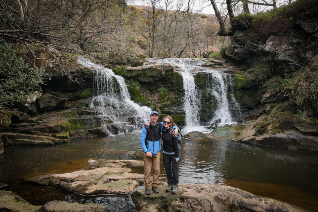
6. Goathland Waterfall Walk
- Type: Loop
- Distance: 10km
- Time: 3–4 hours
- Elevation gain: 300m
- Difficulty: Hard
- Trailhead: Goathland
- Map: AllTrails
Sure, the Goathland Waterfall Walk isn’t anywhere near as well-known as other waterfall walks in Yorkshire, such as the famous Ingleton Waterfalls Trail. However, the Goathland Waterfall Walk is much quieter and more intrepid.
By doing the Goathland Waterfall Walk, you’ll see five waterfalls. These include Walk Mill Foss, Water Arc Foss (AKA Upper Thomason Foss), Thomason Foss, Mallyan Spout and Nelly Ayre Foss. Personally, our favourite waterfall was Water Arc Foss, which is essentially the upper falls of the better-known Thomason Foss.
Read more: Goathland Waterfall Walk – Discover the 5 Goathland Waterfalls

7. Hole of Horcum Circular Walk
- Type: Loop
- Distance: 11.6km
- Time: 3 hours
- Accumulated elevation gain: 200m
- Difficulty: Easy
- Trailhead: Saltergate Car Park
- Map: Wikiloc
The Hole of Horcum Circular Walk is one of the quintessential walks in the North York Moors National Park. Taking place in the Tabular Hills, the walk starts from Levisham Moor, which is a picturesque moorland. You’ll then pass through the charming village of Levisham, before heading up through the spectacular Hole of Horcum.
The Hole of Horcum is a natural bowl formed by a combination of geomorphological processes that have occurred over many years. It’s around 120 metres deep and 800 metres wide and is also known as Yorkshire’s Grand Canyon!
FYI – during the walk, we highly recommend stopping in at The Horseshoe Inn, which is hands-down one of the best pubs in the North York Moors.
Read more: Hole of Horcum Circular Walk – The Ultimate Guide


8. Hawnby Hill Walk
- Type: Out & Back
- Distance: 3km
- Time: 45 minutes
- Elevation gain: 155m
- Difficulty: Easy
- Trailhead: Hawnby
- Map: AllTrails
The Hawnby Hill Walk is one of the most underrated walks in the North York Moors. Starting in the quaint village of Hawnby, you’ll simply walk up and down the hill that overlooks the village.
Hawnby Hill forms part of the western edge of the Tabular Hills and provides excellent views of the surrounding countryside. The top of the hill itself features a somewhat narrow limestone ridge, which is epic in itself.
Some ramblers will include Hawnby Hill as part of a longer circular walk (approx. 11km), which also explores Hawnby Moor and Easterside Hill. However, for a shorter walk, we recommend this out and back route option.
Read more: Hawnby Hill Walk – The Short But Sweet Out and Back Route


9. Cloughton and Hayburn Wyke Walk
- Type: Loop
- Distance: 7.2km
- Time: 2.5 hours
- Elevation gain: 265m
- Difficulty: Moderate
- Trailhead: Hood Lane
- Map: AllTrails
This circular walk combines sections of the Cleveland Way and the Cinder Track, with the highlight of visiting the Hayburn Wyke Waterfall.
Starting in Cloughton, you’ll follow along a lovely coastal path section of the Cleveland Way. Eventually, you’ll reach the unique Hayburn Wyke Waterfall, fed by Hayburn Beck, which flows onto the rocky Hayburn Wyke Beach.
From there, you’ll follow Hayburn Beck upstream, joining the Cinder Track. Feel free to stop in for a refreshment at The Hayburn Wyke Inn, or continue along this serene woodland trail section of the Cinder Track to complete the walk.


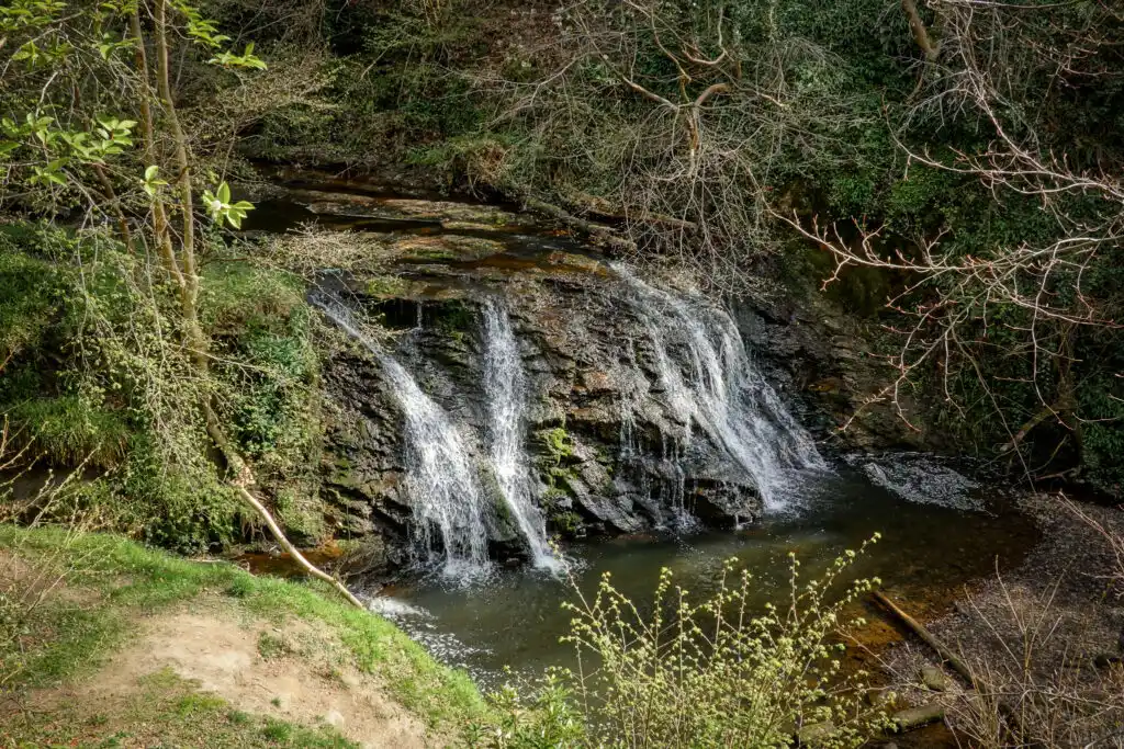
10. Falling Foss Circular Walk
- Type: Loop
- Distance: 3km
- Time: 1 hour
- Elevation gain: 90m
- Difficulty: Easy
- Trailhead: Falling Foss Tea Garden Car Park or May Beck Car Park
- Map: AllTrails
Falling Foss is easily one of the best, if not the best, waterfalls in the North York Moors. The Falling Foss Circular Walk is a short and easy trail that not only visits Falling Foss but also explores the surrounding woodlands, following alongside the quaint May Beck for a large portion of the walk.
Personally, Beck and I visited a second waterfall by slightly extending this walk. Essentially, from the May Beck Car Park, you can follow a faint trail along Blea Hill Beck, which eventually leads to the hidden Blea Hill Waterfall. For more information about how to find this waterfall, please read The 10 Best North York Moors Waterfalls.


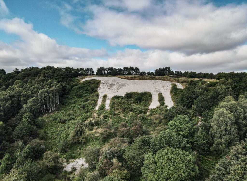
11. Sutton Bank Walk (White Horse Walk)
- Type: Out & Back with Loop
- Distance: 5.5km
- Time: 1.5–2 hours
- Elevation gain: 110m
- Difficulty: Easy
- Trailhead: Sutton Bank National Park Centre
- Map: Wikiloc
The Sutton Bank Walk, which is also known as the White Horse Walk, is one of the most popular walks in the North York Moors. The walk takes place along Sutton Bank Hill, which provides stellar views across North Yorkshire, including views of the Vale of Mowbray and the Valley of York.
Eventually, you’ll reach the well-known Kilburn White Horse – a hillside horse-shaped figure dating back to 1857. By flying our drone, we were able to capture some decent aerial photography of the iconic landmark.
Read more: Sutton Bank Walk (White Horse Walk) – The Ultimate Guide

12. Helmsley to Rievaulx Abbey Walk
- Type: Figure 8
- Distance: 12.8km
- Time: 3–4 hours
- Elevation gain: 225m
- Difficulty: Easy
- Trailhead: Cleveland Way Car Park
- Map: Wikiloc
By doing this walk, you’ll get to see more of the historical attractions in the North York Moors area. The walk takes in views of both Helmsley Castle and Rievaulx Abbey. Of course, you could always pay to enter either of these sites if you want to explore them more during your walk.
Starting in the market town of Helmsley, which is the official starting point of the Cleveland Way, you’ll follow the initial segment of this multi-day trail all the way to Rievaulx Abbey. From there, you’ll take a combination of different paths back to Helmsley, passing Duncombe Park on the way.
Read more: Helmsley to Rievaulx Abbey Walk – The Ultimate Guide


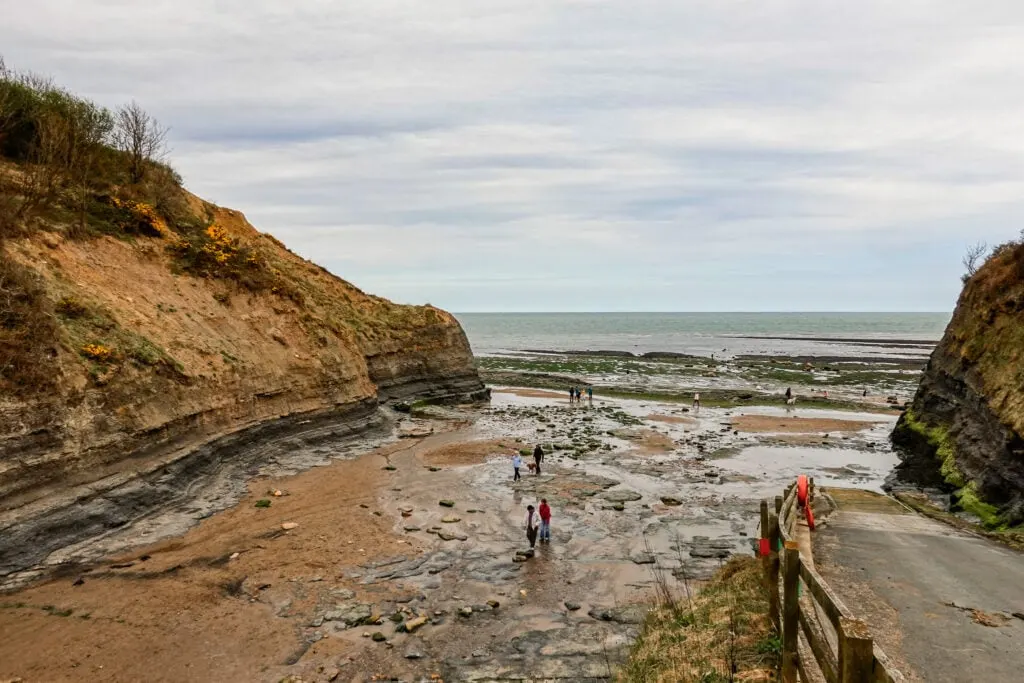
13. Boggle Hole to Robin Hood’s Bay
- Type: Loop
- Distance: 2.3km
- Time: 45 minutes
- Elevation gain: 155m
- Difficulty: Easy
- Trailhead: Boggle Hole Car Park or Robin Hood’s Bay
- Map: AllTrails
The Boggle Hole to Robin Hood’s Bay Walk is another excellent short walk in the North York Moors. Personally, we started the walk at Boggle Hole. If you do the same, you’ll then walk along the beach to Robin Hood’s Bay. Along the way, keep an eye out for sea caves, Jurassic fossils and rock pools.
Once you arrive at Robin Hood’s Bay, you’re free to explore the town as much as you wish. Otherwise, for the walk, you’ll follow the Cleveland Way from Robin Hood’s Bay back to Boggle Hole.
Bear in mind, you should only walk on the beach at low tide. You can check the tide times on BBC Weather, searching for Whitby tide times.

14. Kildale Falls (Old Meggison Falls) Walk
- Type: Out & Back
- Distance: 1.8km
- Time: 15 minutes
- Elevation gain: Minimal to none
- Difficulty: Very easy
- Trailhead: Kildale
- Map: Google Maps
Along the River Leven in Kildale, you’ll find a charming cascade waterfall called Kildale Falls or Old Meggison Falls. The woodland trail, which is a side trail from the Cleveland Way, follows alongside the river to the waterfall.
Unfortunately, the landowner of the area is doing all they can to stop people visiting. This includes fencing off access to the base of the waterfall and blocking trailhead roadside parking. That’s why you’ll need to park closer to Kildale and walk to the waterfall from there, which makes for a longer walk.

The Best Long Distance Walks in the North York Moors
Other than day walks, the North York Moors is also a popular place for thru-hiking. As mentioned, Beck and I haven’t completed any long distance multi-day walks in the area. However, we have walked bits and pieces of several multi-day walks in the North York Moors National Park.
For completeness, here are some brief details about the three best multi-day walks that take place in the North York Moors, or that at least have some sections passing through the national park.
15. Coast to Coast Walk
- Type: One way
- Distance: 295km
- Time: 12–16 days (usually 14 days)
- Elevation gain: 10,100 metres
- Difficulty: Hard
- Trailhead: Saint Bees
- Map: AllTrails
Despite being an unofficial route, Wainwright’s Coast to Coast Walk is one of the most popular multi-day walks in the UK. Starting at Saint Bees on the Irish Sea, the walk goes through the Lake District, the Yorkshire Dales and the North York Moors, finishing in Robin Hood’s Bay on the North Sea.


16. Cleveland Way
- Type: One-way
- Distance: 175km
- Time: 7–11 days (usually 9 days)
- Elevation gain: 5,500m
- Difficulty: Hard
- Trailhead: Helmsley
- Map: AllTrails
As mentioned previously, the Cleveland Way National Trail starts in Helmsley. The trail then passes through the North York Moors to Saltburn. From there, the trail follows the stunning North York Moors coastline all the way to Filey.


17. Cinder Track
- Type: One-way
- Distance: 35km
- Time: 2 days
- Elevation gain: 410m
- Difficulty: Moderate
- Trailhead: Scarborough or Whitby
- Map: OS Maps
The Cinder Track is a former railway line connecting Scarborough and Whitby. Despite being used more typically by cyclists, it’s certainly possible to walk the Cinder Track. Given its length, most walkers complete it as an overnight walk.


The Other Best Walks in North Yorkshire
Of course, many other outstanding walks in North Yorkshire don’t take place in the confines of the North York Moors National Park. You’ll find most of the other best North Yorkshire walks in the Yorkshire Dales National Park.
Yorkshire Dales Walking Guides


Discover all of the best walks in the Yorkshire Dales National Park.
Where to Stay in the North York Moors
Having spent quite a bit of time walking in the North York Moors, we’ve experienced both camping and staying in a traditional pub hotel in the area.
We have camped at Middlewood Farm Holiday Park in Fylingthorpe, located just outside Robin Hood’s Bay. It’s undoubtedly one of the best campgrounds in the North York Moors.
We also stayed at The George & Dragon Hotel in Kirkbymoorside, near Helmsley. If you’re looking for one of the best value pub hotel stays in the North York Moors, we recommend staying there.
Budget North York Moors Accommodation


- The pub and hotel are separate, so you can expect a good night’s sleep
- Excellent pub food and local ales on your doorstep
- A great base for doing walks in the North York Moors
Getting Around the North York Moors
The easiest way to get around the North York Moors to complete these walks is to drive. Of course, depending on which walks you want to do, it’s possible to rely on public transport alone. But by having a car, you’ll undoubtedly be able to experience more walks during your time visiting the national park.
Car Hire


If you don’t have your own car, you should hire one using Discover Cars. Personally, we use Discover Cars and highly recommend them for finding your ideal car hire at an affordable price. Booking online is super easy and the free cancellation policy is great.
Walks in the North York Moors FAQs
Here, we’ll cover some frequently asked questions about walks in the North York Moors.

What Are the Best Circular Walks in the North York Moors?
The Wainstones Walk is our favourite circular walk in the North York Moors. Other excellent circular walks in the North York Moors include the Lord Stones Walk, the Bridestones Walk, the Goathland Waterfall Walk, the Hole of Horcum Walk and the Cloughton and Hayburn Wyke Walk. Certainly, this guide sheds light on all of the best circular walks in the area.
What Are the Best Short Walks in the North York Moors?
In our opinion, the best short walks in the North York Moors include the Roseberry Topping Walk, the Lord Stones Walk and the Bridestones Walk. Other short walks in the area that we highly recommend include the Hawnby Hill Walk, Falling Foss Circular Walk and Boggle Hole to Robin Hood’s Bay.
When Is the Best Time to Walk in the North York Moors?
For better weather, drier paths and longer days, we recommend walking in the North Moors during daylight saving time (April to October).
Do I Need to Pay For Any Walks in the North York Moors?
No, it’s free to walk in the national park. Although you may have to pay to use some car parks.
Please share this blog post on your socials!
Leave a comment