
The Xemxija Heritage Trail is a fantastic historical trail in St Paul’s Bay in Malta. Starting near the majestic Xemxija Bay, the Xemxija Heritage Trail passes no less than 20 archaeological attractions! The trail is quite short at around 4km. So, there are a lot of historical sites to see along the way. To help you navigate the route and also appreciate what you’re exploring, we recommend using some form of Xemxija Heritage Trail map. Otherwise, you may pass several sites without even realising.
In this guide, we’re going to tell you everything you need to know about Malta’s Xemxija Heritage Trail. This will include information about different Xemxija Heritage Trail map options. That way, you’ll be able to truly appreciate what you see and explore on the route. We’ll also list all 20 archaeological sites dotted along the Xemxija Heritage Trail. We’ll then provide additional details for the most impressive sites en route. Finally, we’ll talk a little about Xemija Bay and St Paul’s Bay.
Table of Contents
Xemxija Heritage Trail Malta Overview
The Xemxija Heritage Trail is an excellent walking route in Malta. Admittedly, it surpassed our expectations. Beck and I thought we would enjoy the island’s various coastal walks much more than this historical trail. But, the historical trail is jam-packed with so many untouched and fascinating historical sites, that we were truly blown away. Indeed, this historical trail was just as entertaining and exhilarating as the island’s stunning coastal walks.
As mentioned, to truly appreciate what you’re seeing on the Xemxija Heritage Trail, it’s best to follow some sort of map. Below, we’ll provide a GPS-guided map. We’ll also tell you where you can find a free map to use in St Paul’s Bay. In addition, we’ll provide details on using an app to help with navigation and information about the sites en route.
Read our Tas-Silġ Walk, Golden Bay to Ġnejna Bay and Dwejra Lines guides


Xemxija Heritage Trail Map and Details
- Type: Figure 8
- Distance: 3.8km
- Time: 1.5 hours
- Accumulated elevation gain: 60m
- Difficulty: Very easy
- Trailhead: Google Maps – Start of Xemxija Hill Heritage Walk
- Map: Wikiloc
This GPS-guided map will obviously help you navigate the Xemxija Heritage Trail in Malta. But, we haven’t added information about the sites onto this map. If you’d like a more informative map, which includes information about the sites and exactly where to find them, you can pick up a free map in St Pauls Bay. Head to St Paul’s Bay Tourist Information Centre or St Paul’s Bay Local Council.
Top 3 Malta Tours


Xemxija Heritage Trail App
Downloading the Xemxija Heritage Trail app is another navigation option, which may be even better than a standalone map. By using the app, there’ll be a digital map to follow, showing you exactly the location of all 20 archaeological sites. The app also provides in-depth historical information about all of the sites.
Xemxija Heritage Trail Description
Before we start the Xemxija Heritage Trail description, let’s go through the 20 archaeological sites that you’ll see en route.
- Roman Road (Pilgrims Way)
- Dry Stone / Rubble Walls (Tas-Sejjieh)
- Menhir
- Cave of the Galley
- The Roman Apiaries
- 1,000 Year Old Carob Tree (Ceratonia Siliqua)
- The Cave of Burials
- Neolithic Temple
- Corbelled Hut (Girna)
- Woodland
- Punic Tomb
- Farmer’s Hut (Gorbog)
- Cave Dwellings
- Granary (Silo)/Well
- Neolithic Tombs
- WWII Defence Post (Pill Box)
- Roman Baths
- The Farmhouse (Razzett)
- Mistra Gate
- Cart Ruts (Raddet Ir-Roti)
In the trail description below, we’ll talk about the most impressive attractions on the Xemxija Heritage Trail. Essentially, we’ll highlight what we thought were the best parts of the walk.
FYI – don’t expect any considerable in-depth historical explanation of the sites in our trail description. For more historical facts and information, we recommend downloading the Xemxija Heritage Trail app.
Travel Insurance


Don’t leave for your trip without booking travel insurance. We all know accidents can happen and having Heymondo travel insurance could save you thousands of dollars if something goes wrong. Click the button below to receive a 5% discount!
Roman Road (Pilgrims Way)
Starting near Xemxija Bay, the trailhead for the Xemxija Heritage Trail is signalled by a road sign, which reads ‘The Roman Road’. Indeed, the walk begins on a 2000 year old Roman road, also known as Pilgrims Way. Back then, the road was used by pilgrims to get to the Sanctuary of Our Lady of Mellieħa. Right from the get-go, Beck and I were amazed by how long the road had been in existence. After a slight incline, you’ll pass dry stone rubble walls before arriving at the Cave of the Galley.


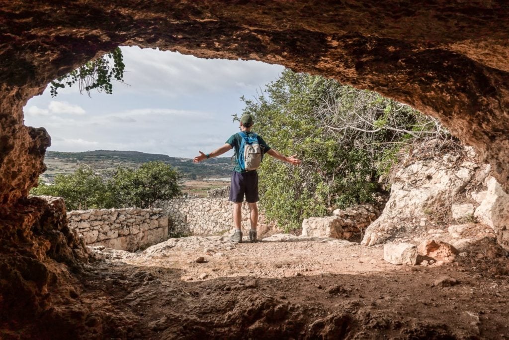
Cave of the Galley
The Cave of the Galley is the first of the caves that you’ll explore during the Xemxija Heritage Trail. It’s only a small cave, but it’s possible to enter and explore inside. The cave once served as a dwelling, although historians think it was originally a tomb site. From inside the cave, you’ll enjoy nice views of coastal areas such as Xemxija Bay and St Paul’s Bay. Once you’ve scoped out the cave, it’s time to continue on the trail towards the Roman Apiaries.


The Roman Apiaries
The Roman Apiaries are an outstanding attraction on Malta’s Xemxija Heritage Trail. They date back to Punic-Roman times. Basically, the apiaries are where bees used to be kept to produce honey. Feel free to explore inside the apiaries. You’ll notice the inside and outside of the cave have been purposefully carved out to create structures for housing the bees. The apiaries are truly fascinating to explore. Just outside of the apiaries, you’ll find a mind-blowingly large old tree!


1,000 Year Old Carob Tree (Ceratonia Siliqua)
The Carob Tree located out the front of the Roman Apiaries is over 1,000 years old. In fact, this tree found on the Xemxija Heritage Trail is the oldest tree in Malta! It’s nearly seven metres wide with many thick meandering roots scattered along the ground.
Next, you’ll arrive at the second cave of the walk – the Cave of Burials.


The Cave of Burials
The Cave of Burials is a similar size to the Cave of the Galley but has a much larger opening. In contrast to the Cave of the Galley, the Cave of the Burials served a different purpose. As the name suggests, the Cave of Burials was used for burials back in the day. Other than the cave itself being particularly interesting, the area outside the cave is a great vantage point. Again, you’ll enjoy views of Xemija Bay and St Paul’s Bay.

Neolithic Temple and Corbelled Hut (Girna)
Further on, you’ll reach a sign, clarifying the direction of other archaeological sites. This is where a map of the Xemxija Heritage Trail comes in handy. If you follow the directions of the sign on the trail, you’ll head straight to the Punic Tomb, missing out on some other attractions. If you have a map, you’ll see that there are other attractions on the Xemxija Heritage Trail worth seeing before going to the Punic Tomb. With that in mind, when you arrive at this sign on the trail, we recommend following the dirt path left. From there, you’ll initially see a Neolithic Temple, which is now just a pile of rocks.
Walking further into the woodlands, you’ll reach an interesting corbelled hut at the end of the path. Historians think these stone huts were used for residential purposes. You’ll find these sorts of structures all over Malta if you know where to look! Anyway, from there, you’ll complete a loop back to the original signpost, where you’ll then head in the direction of the Punic Tomb.
Punic Tomb
The Punic Tomb is yet another fascinating historical attraction on this walk. The tomb dates back to approx. 500BC. The rectangular shaft is around two metres deep and leads to a burial chamber. If you want to see some footage of Punic Tomb, watch from minute 10:12 of our Malta Hiking YouTube production. After exploring Punic Tomb, you’ll arrive at a dilapidated hut.
Farmer’s Hut (Gorbog)
Admittedly, Farmer’s Hut doesn’t look like much of a hut at all these days. What remains is one wall of a stone building with fallen rocks beside it. It’s located next to some large cave dwellings. It’s thought that the hut previously served as an extension to the cave dwellings for the purpose of storage. Given the lack of structural integrity, you’ll likely bypass the Farmer’s Hut for the large cave dwellings.
Cave Dwellings
The cave dwellings found next to the Farmer’s Hut are much larger inside compared with the previous caves seen on the Xemxija Heritage Trail. You’ll certainly want to explore inside the cave dwellings, imagining what it would have been like to live there. Apparently, these dwellings were occupied as late as the 1930s. Additionally, they were used during WWII for protection from air raids.
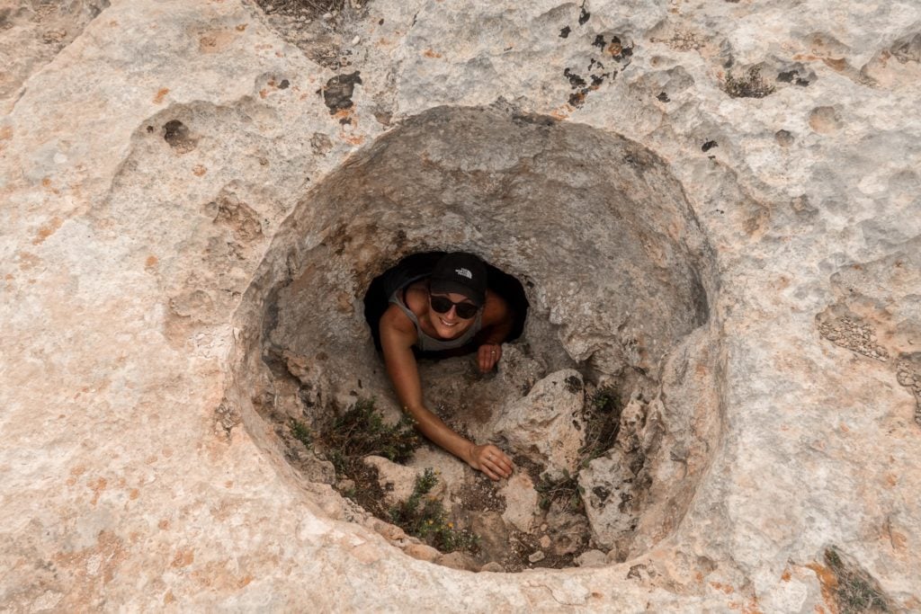
Granary (Silo)\Well
Not far from the cave dwellings, you’ll arrive at a fairly substantial hole in the rock. This deep silo cut in the rock was once used as a granary to store grain. But, there’s also evidence to suggest it was later used as a well for water storage. Either way, Beck enjoyed climbing in and out of the hole!

Roman Baths
Once you’ve explored the cave dwellings, you’ll continue towards a set of apartments. Again, this is where a map of the Xemxija Heritage Trail is helpful. It’s easy to miss one of the major highlights of the walk – the Roman Baths. Make sure, that once you arrive at the road next to the apartments, turn left and then right on a dirt path. This will lead you to the impressive Roman Baths.
Amazingly, these Roman Baths were only discovered in the last 20 years. Beck and I couldn’t believe more isn’t made of this incredible historical site! Exploring the Roman Baths was possibly our favourite part of the entire walk.


The Farmhouse (Razzett)
Just outside and below the Roman Baths, you’ll find the Farmhouse. Honestly speaking, the Farmhouse is nothing too special. It’s just an old typical house that farmers, back in the day, would have lived in. Certainly, the Farmhouse is overshadowed by the immensity of the Roman Baths.
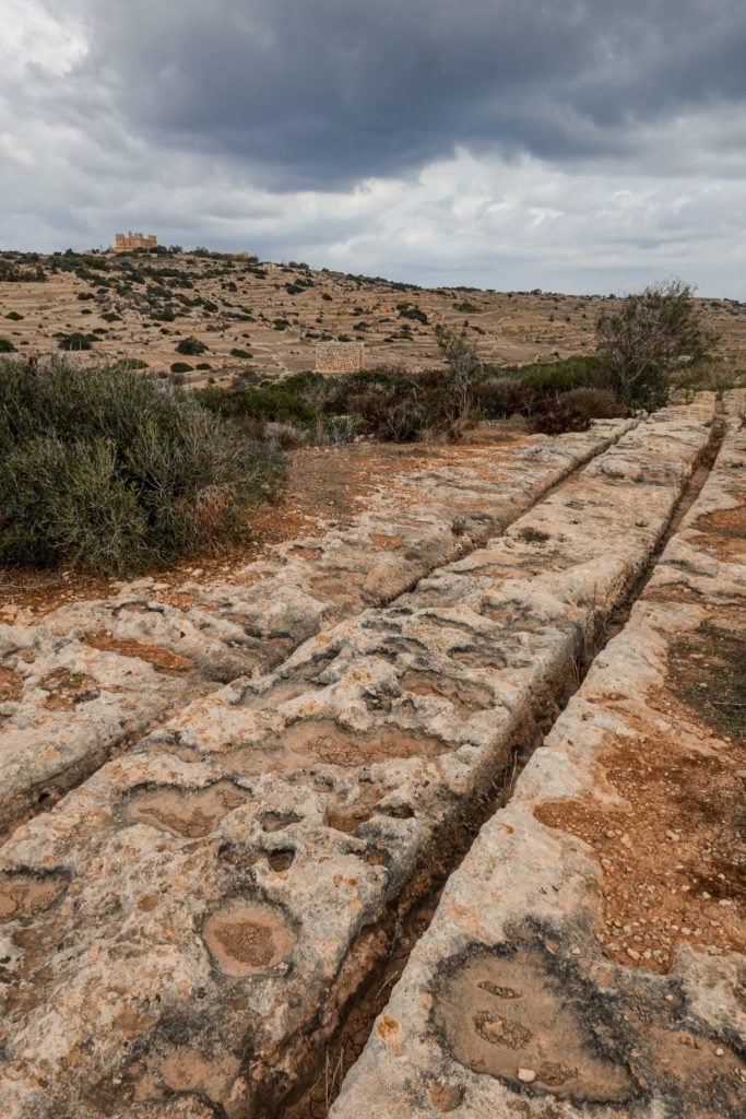
Cart Ruts (Raddet Ir-Roti)
The final attraction of the Xemxija Heritage Trail is a well-defined set of cart ruts. Truth be told, you can find cart ruts like this all over the island. But, these cart ruts are one of the best-preserved that you’ll find. It’s likely that the lines were caused by the heavy wheels of carts eroding the soft limestone over time.

After scoping out the cart ruts, you’ll finish the walk by heading back towards the Roman Road. It wasn’t a long distance to finish the walk. Admittedly, we were keen on an iced coffee and pastizzi at Xemxija Cafe Lounge & Pizzeria in Xemxija Bay!
Xemixija Bay
After completing the walk, we recommend heading to Xemxija Bay. It’s a fairly large bay, located in Xemxija – a suburb in the western part of St Paul’s Bay in northern Malta. At Xemxija Bay, you’ll find some bars, cafes and restaurants to relax in after the walk. Otherwise, order take-away and find a seat along the lovely Xemxija Bay.


St Paul’s Bay
As mentioned, the town of Xemxija is located on the western edge of St Paul’s Bay, which is the largest town in the northern region of Malta. Besides the capital of Valletta, St Paul’s Bay is one of the most popular places to stay in Malta. It’s exactly where Beck and I stayed during our trip. Admittedly, there are much nicer areas and less-crowded bays to explore in Malta. So, other than doing the Xemxija Heritage Trail in St Paul’s Bay, we see no other particular reason to hang out there to explore.
How to Get to the Xemxija Heritage Trailhead
The simplest and quickest way to get to the trailhead for this walk is to drive there yourself. We parked for free here out the front of Xemxija Bay.
We hired a manual car from Malta International Airport for only €17/day ($17USD). It’s possible to get a cheaper manual car, but from car rental companies with a poorer reputation. Alternatively, for an automatic car, you’d be looking at around €22/day ($22USD) with a reputable company.
Car Hire


If you don’t have your own car, you should hire one using Discover Cars. Personally, we use Discover Cars and highly recommend them for finding your ideal car hire at an affordable price. Booking online is super easy and the free cancellation policy is great.
To find out more about renting a car with Discover Cars, read our Discover Cars review and Discover Cars Insurance review.
If you’re using public transport, you’ll ideally catch the 41, 42, 49 or 250 bus from Valletta to Xemxija. If you’re heading to Xemxija from an alternate destination, head to Malta Public Transport to plan your trip.
Hiking Essentials
These are our five hiking gear essentials for this walk.
Osprey Skarab 30


The Osprey Skarab 30 is our go-to hiking backpack for day hikes. This well-designed unisex backpack is comfortable and spacious, so you’ll have plenty of space to pack everything without feeling the strain on your upper back.
Osprey Ultralight Raincover


A waterproof backpack cover is an absolute must when you’re adventuring outdoors. The Osprey Ultralight Raincover Medium is a high-quality waterproof cover that’ll keep your backpack bone dry.
GRAYL Reusable Water Bottle


The GRAYL GeoPress is the best water filter bottle that allows you to purify 710mL (12 ounces) of water. This bottle will make water safe to drink wherever you’re hiking.
BUFF Original Ecostretch


The BUFF Original Ecostretch is a great option when it comes to multifunctional headwear. We use the Ecostretch as a neck gaiter to keep the sun off our necks and it helps us keep warm in cooler climates.
Sony Cybershot RX100 VII


Capture epic photos and videos with the Sony Cybershot RX100 VII. This is hands-down the best compact camera. We love using this simple point-and-shoot camera when we’re hiking as it’s lightweight and durable.
To find out more about all of the gear that we use and recommend, read our guides about our favourite hiking gear, travel gear and camera gear. Otherwise, read our comprehensive travel packing checklist.
It can get very hot in Malta, particularly during the peak season in summer. Make sure to also pack plenty of water, snacks, sunscreen and a hat.
Bonus Tips
- Extend the walk: north of Xemxija, you can follow a road that passes through the luscious Mistra Valley and leads you to a lovely pebbled beach called Mistra Bay.
- Another great heritage trail in Malta: consider the Manikata Heritage Trail.
- Other things to do in Malta: visit Malta’s old towns like Valletta and Mdina. Otherwise, the most popular activities in Malta are usually water-based. Consider doing a tour by boat!
- Don’t just hike on the mainland: the Comino Walk and Gozo’s Xlendi Walk and Dwejra Walk are brilliant coastal trails on Malta’s islands.
Read our Malta Hiking Guide to learn about the island’s nine best walking (or running) routes.
Hi everybody!
A question about Heritage trail in Malta.
At the end of the trail, am I obliged to go back by the same way or is there any exit?
Thank you by advance
Muriel
Hi Muriel,
Thanks for reading and commenting.
You aren’t obliged to go back the same way, although this tends to be a more common way to walk the trail. There are several possible exit points throughout the walk.
Have a great time in Malta.
Cheers,
Dan