
The Laguna Yanacocha and Laguna Uruscocha hike is an excellent trail option near Huaraz in Peru. It’s one of the lesser-known day hike options in the stunning Cordillera Blanca. Indeed, not many tourists visiting Huaraz will do this hike. But, Beck and I highly recommend it for many reasons.
Firstly, both Laguna Yanacocha and Uruscocha are stunning. Plus, they’re positioned at the foot of the immense Urus Mountain – what a scene! Secondly, it’s fairly easy to visit. From Huaraz, you’ll initially head to nearby Paltay, before making your way to the trailhead in Pashpa. Thirdly, this hike is a fantastic acclimatisation hike option to prepare yourself for higher altitude hikes in the area.
In this ultimate guide, we’ll detail everything you need to know about this hike. We’ll provide the hiking specs and a GPS-guided map. Afterwards, we’ll detail the hike itself, before explaining exactly how to get there. Whilst we’re at it, you’ll find recommendations for other epic hikes in and around Huaraz.
Table of Contents
Laguna Yanacocha and Uruscocha Overview
By doing this hike, you’ll explore the exceptional Laguna Yanacocha and Uruscocha. By doing a quick Google search, you may have found that there are a number of lakes in Peru with the name – Laguna Yanacocha. Perhaps the most well-known Laguna Yanacocha is located in the department of Cusco, near Ollantaytambo in the Urubamba (Sacred Valley). Just to be clear, we’re obviously not talking about that lake in Cusco. In this guide, we’re talking about Laguna Yanacocha, which is found next to Laguna Uruscocha, at the foot of Urus Mountain in the outstanding Cordillera Blanca. FYI – Laguna Uruscocha is also known as Lake Uruscocha or Uruscocha Lake.
The hike to Laguna Yanacocha and Uruscocha is actually one of the hardest day hikes in the Huascaran National Park. Honestly speaking, the trail itself took Beck and I by surprise. Compared with many other day hikes near Huaraz, trail navigation was much more challenging. From the few other hikers that we know who have done this trail, they all mentioned getting lost at some stage. In addition, there’s quite a lot of elevation gain on undefined trail. To that end, by reaching both lakes at the foot of Urus Mountain, you’ll feel a great sense of accomplishment.
To make sure you don’t get lost, download our GPS-guided map and read our trail description. The latter is where we detail the main spots where trail navigation is difficult.
Read our Laguna Humantay, Laguna Paron and Laguna 69 guides


Where Is Laguna Yanacocha and Uruscocha?
Both lakes are found in the Valley of Ishinca in the Huascaran National Park. They’re located near the small village of Pashpa, which is easy to get to from Huaraz, via Paltay. Huaraz is actually the capital of the Ancash region in Northern Peru. From Huaraz, you’re just a stone’s throw away from Paltay, which isn’t too far from the trailhead in Pashpa.
Read How to Get to Laguna Yanacocha and Uruscocha for the specifics on reaching the trailhead from Huaraz. Here’s an interactive map of the area.
Laguna Yanacocha and Uruscocha Hike Details & Map
- Type: Out & Back
- Distance: 17km
- Time: 5–7 hours
- Accumulated elevation gain: 840m
- Difficulty: Moderate
- Trailhead: Pashpa (near Huaraz)
- Map: Wikiloc
Laguna Yanacocha and Uruscocha Hike: Trail Description
After reaching the small village of Pashpa from Paltay, which is near Huaraz, you have two options. You can start the hike from Pashpa village, or, start where the road leading from the village to the mountains ends. We chose to hike from the village as we were interested in scoping out this humble mountain settlement. But, by starting at the road’s ends (we’ve labelled as ‘Alternate Trailhead’ below), you’ll shave around 4.2km off the hike. That’ll make it an approx. 13km out and back. By doing this, you’ll also avoid some of the aggressive dogs in the town of Pashpa. Again, read How to Get to Laguna Yanacocha and Uruscocha for more details on reaching either starting place.


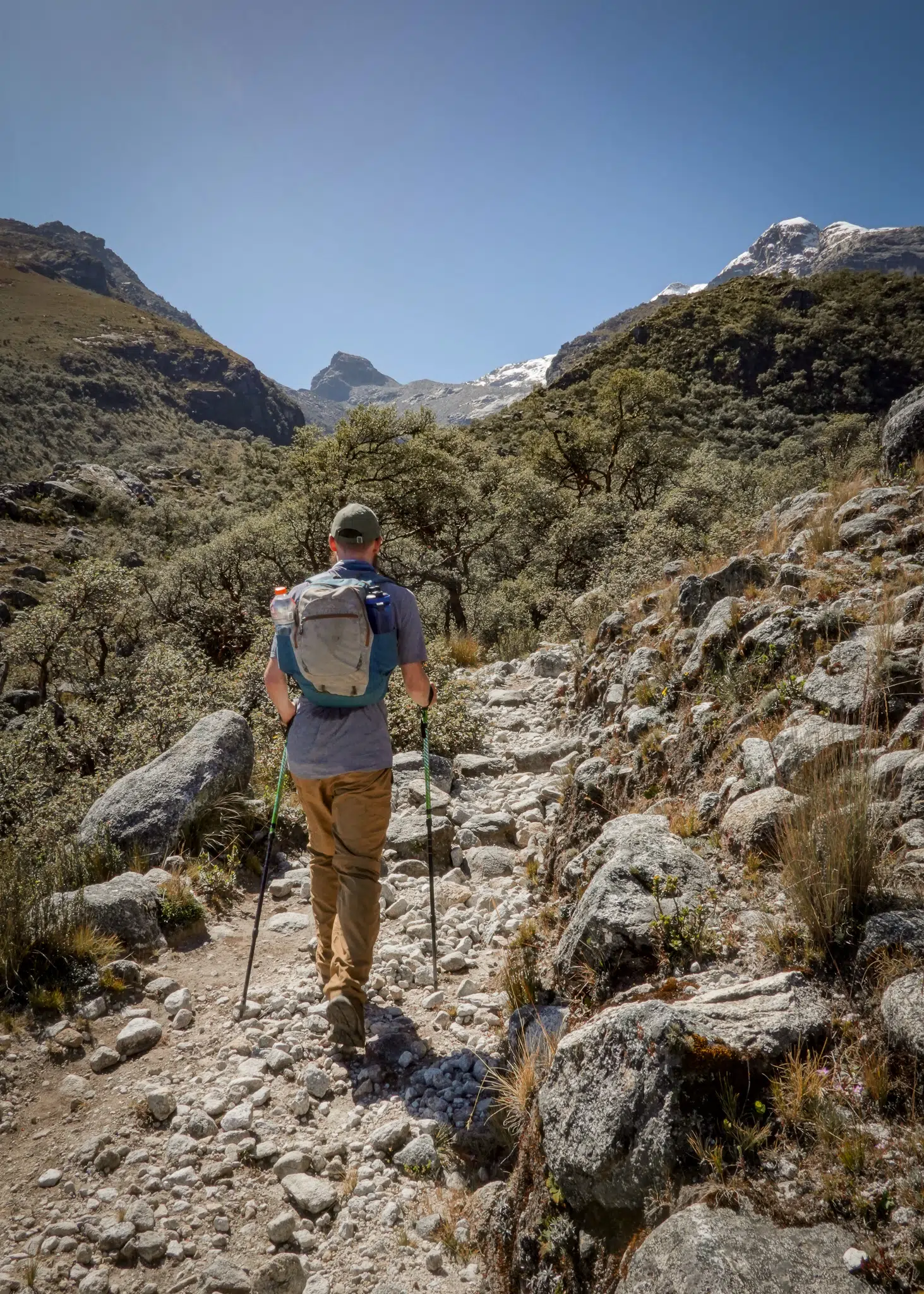
Starting from Pashpa, we meandered our way around the village. If you’re also starting the hike from here, you’ll soon join an unpaved road, that cuts through farmland and passes a small body of water. The unpaved road transitions into a grassy farm track, which eventually ends as you approach pockets of trees.
As you gradually ascend, the trail transitions once more. This time, into a dirt track. Soon enough, you’ll reach a sign, marked ‘P.C. Ishinca’. Here, it’s really important that you stop following this defined trail that leads to Nevado Ishinca.


Instead of following this trail, you’ll turn left, following a barely defined trail, which steeply ascends a hill. Most hikers miss this turning point and unknowingly lose the trail to Laguna Yanacocha and Uruscocha, instead, continuing on the Ishinca Trail.


Soon after this turning point, you’ll pass a beautiful unidentified lake. From here, navigation is challenging as the trail seems to constantly disappear and randomly re-appear.
Urus Mountain and the Lagoons
After hiking through fairly arid terrain, you’ll soon reach a dense and luscious forest. This is where trail navigation is most difficult. There are some sections of defined trail, that assist in your ascent. But, admittedly, most of the time, it’s guesswork. At least, Urus Mountain becomes more defined and offers a beautiful distraction during the tough climb through the forest.


After a steep climb, the trail flattens, veering to the right towards the elegantly green-toned Laguna Yanacocha. It’s a truly welcome sight after a challenging hike. But, that’s just one of the lakes!


After passing Laguna Yanacocha, there’s a brief uphill climb, that’ll lead you to a nice vantage point of Laguna Uruscocha. If anything, Laguna Uruscocha is the more impressive of the two lakes. It also has an incredible green tinge. But, it’s much larger in size. In addition, you’ll enjoy even better views of the Urus Mountain complex from the shores of Laguna Uruscocha. In fact, other than Urus Mountain, you’ll also get a look at the south side of Huascaran and Hualcan Copa. Sit down, relax and enjoy the views.


After soaking in the views of Urus Mountain and Laguna Uruscocha, it’s time to retrace your steps to complete the hike. You’ll hike mostly downhill back to Pashpa before heading back to Huaraz via Paltay. During the descent, which heads away from Urus Mountain and the lagoons, Beck and I dabbled in some speed hiking. So, before we knew it, we were back in Pashpa and making our way to Huaraz.


How to Get to the Laguna Yanacocha and Uruscocha Trailhead
From Huaraz, you’ll catch a colectivo to Paltay and then take a taxi to Pashpa. To our understanding, there are no colectivo services running between Paltay and Pashpa. Well, if there are, the service is extremely limited.
Colectivo from Huaraz to Paltay: you can jump in any colectivo heading towards Caraz. This means you could catch a colectivo heading to Carhuaz, Yungay or Caraz itself. But, personally, Beck and I caught the Linea 10/E colectivo service heading in the direction of Caraz to Jangas. Paltay is located just before Jangas. So, you’ll need to ask the driver to alight at Paltay. Make sure you get off at the river, which is located next to the road entrance that leads to the town of Pashpa. If you go all the way to the town of Paltay, you’d have gone too far! The Linea 10/E service runs from Huaraz to either Jangas, or, in the opposite direction to Recuay.
To ensure you catch the Linea 10/E service, heading to Jangas, make sure to catch the colectivo from the west side of Centro Mercado. The journey from Huaraz to Paltay takes around 30 minutes and costs approx. S/4 ($1USD).
Taxi from Paltay to Pashpa: after arriving from Huaraz, hopefully, you’ll find a taxi waiting at the road entrance for Pashpa. Personally, we recommend German Mendoza, who’s a kind taxi driver from the area. To pre-organise your taxi with him, contact him on Whatsapp (+51945792307). He drove us to Pashpa and then picked us up from there for S/50 ($12USD). If you want to get driven to the alternate trailhead at the road’s end, for a shorter hike, and get picked up from there, that’ll cost S/70 ($18USD). The drive time from Paltay to Pashpa is around 45 minutes.
Paltay, Huaraz
Paltay is a small mountain town just outside of the city of Huaraz. It takes around 30 minutes to drive from Huaraz to Paltay. Honestly speaking, other than doing this hike, there’s no other particular reason to visit Paltay from Huaraz.
Pashpa, Huaraz
Pashpa is an even smaller mountain town located outside of Paltay. From Huaraz, the journey time to Pashpa, via Paltay, takes around 1.5 hours. As mentioned, Pashpa is the starting point of the hike to Laguna Yanacocha and Uruscocha. But, Pashpa is also a potential starting place for several multi-day hikes involving Nevado Ishinca. From Pashpa, you’ll enjoy stunning views of Cordillera Blanca, with the stunning Urus Mountain in the mix.
Laguna Yanacocha and Uruscocha Tours
The hike to Laguna Yanacocha and Uruscocha is not as well known as other day hikes in the area. But, you’ll find most Huaraz-based tour companies offer this day hike as a tour option. Personally, we recommend visiting independently as described above. But, if you’re interested in doing a tour, we suggest giving Qorianka a look-in.
Basically, they offer roundtrip transportation from Huaraz and a guide. For bigger groups (+14 people), the cost is $30USD each. This is fairly good value. But, it may be hard to find a group of this size, as the hike isn’t a popular touristic trail. Admittedly, the private service options are quite expensive. But, for a private group of six or eight people, you’re looking at $45USD and $35USD, respectively. Thankfully, bartering is possible for a cheaper price. In addition, it’s possible to organise transport without a guide, which will considerably lower the price.
FYI – as far as we’re aware, there is no entrance fee for the Laguna Yanacocha and Uruscocha hike. This is despite entering the Huascaran National Park, which usually involves a S/30 ($8USD) daily entrance fee.
Best Time to Visit
You’ll have a better chance of good weather in the dry season, which runs from May to October in Peru. As you’re now aware, this hike isn’t a typical hike for tourists (for now). So, even when hiking during peak tourist times in the dry season, you won’t see many, if any, people on the trail. Personally, Beck and I didn’t see any other hikers on the trail. When Beck and I visited during the dry season, in late June, we had mostly clear skies. But, of course, mountain weather is unpredictable.
How to Acclimatise
Before you do this hike, you should acclimatise. Altitude sickness (AKA Acute Mountain Sickness) is a common illness experienced by those who reach unaccustomed high altitudes. The main symptoms include headache, shortness of breath, nausea, lightheadedness, dizziness, indigestion and loss of appetite. It’s impossible to predict who’ll get altitude sickness. Even if you have avoided it in the past, that doesn’t guarantee that you won’t get it the next time!
Essentially, the single most important way to reduce your chances of altitude sickness is to avoid going up too high, too quickly! Generally speaking, you shouldn’t go higher than 500 metres a day, once you’re beyond 2,000 metres above sea level.
In practice, if you arrive in Huaraz (3,050 metres above sea level), you should have at least two days’ rest before you hike. This will give your body time to adjust and acclimatise. In theory, by the third day, your body should be able to tolerate approx. 3,550 metres. By this time, you should start with some hikes with a lower maximum altitude. For example, you could start with Laguna Wilcacocha (3,710m). You could also hike to Laguna Shallap (4,250m) before attempting the hike to Yanacocha and Uruscocha (4,270m).
How to Avoid Altitude Sickness
There are other ways you can reduce your chances of getting altitude sickness. Firstly, don’t rush when you’re hiking to the lakes at the foot of Urus Mountain. Walk slowly and take it easy. If you feel out of breath, stop and have a break. Secondly, eat light meals and don’t eat them too quickly. Staying hydrated by drinking plenty of water is also very important. In addition, you may benefit from coca leaves, tea or sweets. This is what locals recommend. Finally, there are altitude sickness tablets (such as Diamox) available. But, if you acclimatise properly, you shouldn’t need them.


Where to Stay in Huaraz
If you’re doing this hike from Huaraz, you’ll need a place to crash. We’ve handpicked the best budget, mid-range and luxury options.
- Budget – Accommodation Bella-Vista: this is a brilliant option for the shoestring traveller. At Accommodation Bella-Vista, you’ll have a nice stay in a dorm room that’s great value for money.
- Mid-range – Krusty Hostel B&B: Beck and I really enjoyed our stay here. We stayed in Huaraz for over a month. So, we got to know Krusty Hostel B&B really well. The private rooms are nice and cosy. Also, the hostel features a large shared kitchen, which includes a free breakfast. Did we mention the Wifi is top-notch?
- Luxury – Cordillera Hotel: this is probably one of the best accommodation options in Huaraz. Cordillera Hotel is an excellent hotel with stylish rooms and modern facilities. We doubt there are many nicer places to stay in Huaraz.


Travel Insurance in Huaraz
Heymondo is one of the best budget travel insurance providers on the market. They provide comprehensive travel and medical insurance that won’t break the bank. Whether it’s single trip insurance, annual multi-trip insurance or long stay insurance, Heymondo offers affordable travel and medical insurance to suit all of your needs. Personally, we use Heymondo travel insurance and highly recommend it. To find out more about Heymondo travel and medical insurance, read our Heymondo travel insurance review.
Travel Insurance


Don’t leave for your trip without booking travel insurance. We all know accidents can happen and having Heymondo travel insurance could save you thousands of dollars if something goes wrong. Click the button below to receive a 5% discount!
Other Hikes in Huaraz
There are so many amazing day hikes and multi-day hikes to do in and around Huaraz. We highly recommend doing the following trails:
- Laguna Wilcacocha: an ideal acclimatisation trek to get the ball rollin’ with your Huaraz hiking trip.
- Laguna 69: a popular day hike to a turquoise-coloured lake.
- Four Lagunas Trek: our favourite day hike in the area.
- Laguna 513: another turquoise-coloured lake, that’s even better than Laguna 69!
- Paron Lake: another popular day hike from Huaraz.
- Pastoruri Glacier: a short high-altitude hike to an outstanding glacier.
- Laguna Churup: another day hike that’s easy to do independently.
- Laguna Llaca: is probably the most underrated day hike in Cordillera Blanca.
- Huayhuash Trek: whether you do the Huayhuash Mini Trek in 5 days or the Classic 8 day route, Cordillera Huayhuash has plenty on offer.
- Laguna Hualcacocha: another hike that visits a beautiful turquoise-coloured lake.
- Laguna Queshquecocha: one of the least known hikes in the area.
- Santa Cruz Trek: trekking Santa Cruz is a must-do multi-day hike. We highly recommend adding an out and back to Laguna Arhuaycocha (Alpamayo Base Camp) whilst you’re at it.
- Laguna Rajucolta: one of the easiest day hikes in the Cordillera Blanca.
- Laguna Shallap: this lake has an even more spectacular green colour than Yanacocha and Uruscocha!
What to Wear and Pack
Osprey Skarab 30


The Osprey Skarab 30 is our go-to hiking backpack for day hikes. This well-designed unisex backpack is comfortable and spacious, so you’ll have plenty of space to pack everything without feeling the strain on your upper back.
Osprey Ultralight Raincover


A waterproof backpack cover is an absolute must when you’re adventuring outdoors. The Osprey Ultralight Raincover Medium is a high-quality waterproof cover that’ll keep your backpack bone dry.
GRAYL Reusable Water Bottle


The GRAYL GeoPress is the best water filter bottle that allows you to purify 710mL (12 ounces) of water. This bottle will make water safe to drink wherever you’re hiking.
BUFF Original Ecostretch


The BUFF Original Ecostretch is a great option when it comes to multifunctional headwear. We use the Ecostretch as a neck gaiter to keep the sun off our necks and it helps us keep warm in cooler climates.
Sony Cybershot RX100 VII


Capture epic photos and videos with the Sony Cybershot RX100 VII. This is hands-down the best compact camera. We love using this simple point-and-shoot camera when we’re hiking as it’s lightweight and durable.
To find out more about all of the gear that we use and recommend, read our guides about our favourite hiking gear, travel gear and camera gear. Otherwise, read our comprehensive travel packing checklist.
You should also pack water, snacks, lunch, sunglasses, sunscreen and a hat.
Bonus Tips
- Climbing is another popular activity in Huaraz: other than trekking, many travellers head to Huaraz to climb. If you’re a beginner, give Nevado Mateo a go!
- Use Busbud: we used Busbud to book our bus from Lima to Huaraz. The website is super easy to use and allows you to book well in advance.
- Use a map for this hike: whether it’s a paper map or our GPS-guided map, you’ll want help with trail navigation.
Booking Buses


Busbud is one of the best online bus booking platforms. Wherever you’re travelling, you can easily compare bus tickets from different companies and book the best option for your trip. We highly recommend using Busbud to find the cheapest bus fares.


Please share this article on Facebook. Let’s spread the word on this lesser-known hike that’s easy to do from Huaraz.
Leave a comment